|
|
|
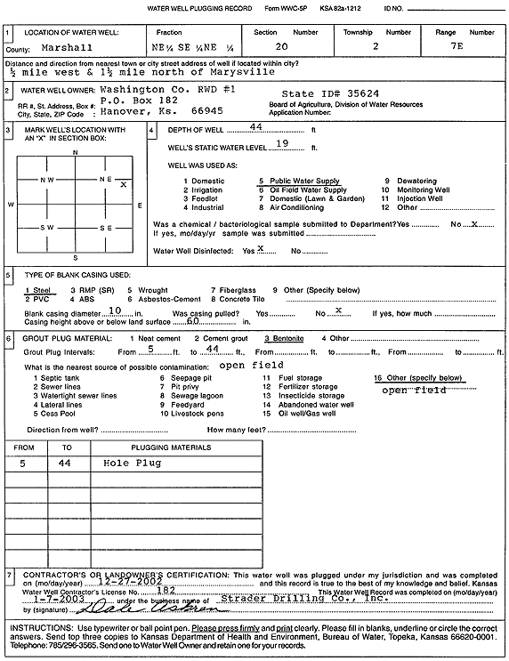
Specific Water Well Detail |
|
|
| Location Info | |||
| Owner: Washington Co. RWD 1 | Status: Plugged | ||
| Location: T2S, R7E, Sec. 20, NE SE NE | County: Marshall | ||
| Directions: from Marysville: .5 mi W, 1.5 mi N | |||
| Latitude: 39.8665627 | Longitude: -96.658454 | Datum NAD 27 | |
| Latitude: 39.8665647 | Longitude: -96.6587525 | Datum NAD 83 | |
| Longitude and latitude calculated by Survey from township-range-section-quarter calls. Only good to within the quarter call accuracy. | |||
| View well on interactive map | |||
| General Info | ||
| Well Depth: 44 ft. | Elevation: ft. | |
| Static Water Level: 19 ft. | Est. Yield: gpm. | |
| Comp. Date: 27-Dec-2002 | Well Use: Public Water Supply | |
| DWR Applic. #: 35624 | Other ID: | |
| Links | |
| No Wizard information available. | |
| View info from WIMAS Water Right Data base... | |
| Driller Info | ||
| Driller: Strader Drilling Co., Inc. | License #: 182 | |
| Scanned Form | View scan |
| Casing Info | ||
|
Casing Type:
Diam: in. Casing height above land surface: in | ||
| Grout Info | ||
| Grout used: | From: to ft | |
| Source of Possible Contamination | ||
| Source: | ||
| Direction from well: | Distance: ft | |