|
|
|
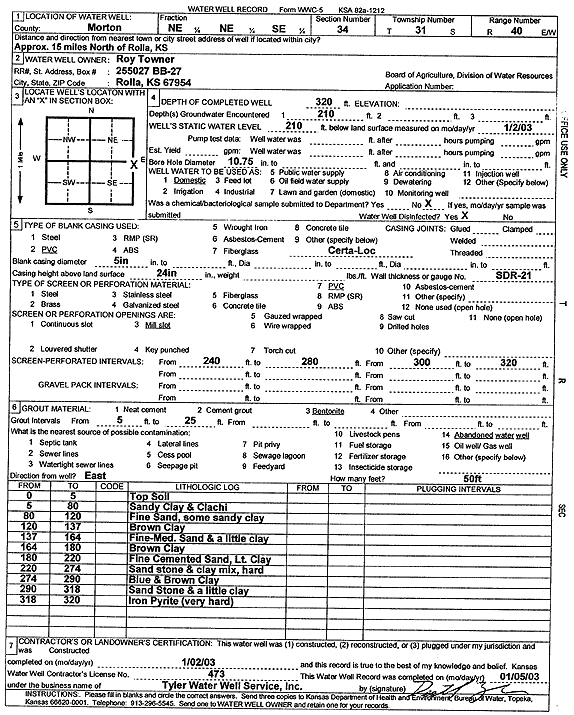
Specific Water Well Detail |
|
|
| Location Info | |||
| Owner: Towner, Roy | Status: Constructed | ||
| Location: T31S, R40W, Sec. 34, NE NE SE | County: Morton | ||
| Directions: from Rolla, 15 mi N | |||
| Latitude: 37.3077177 | Longitude: -101.647179 | Datum NAD 27 | |
| Latitude: 37.3077406 | Longitude: -101.6476207 | Datum NAD 83 | |
| Longitude and latitude calculated by Survey from township-range-section-quarter calls. Only good to within the quarter call accuracy. | |||
| View well on interactive map | |||
| General Info | ||
| Well Depth: 320 ft. | Elevation: ft. | |
| Static Water Level: 210 ft. | Est. Yield: gpm. | |
| Comp. Date: 02-Jan-2003 | Well Use: Domestic | |
| DWR Applic. #: | Other ID: | |
| Driller Info | ||
| Driller: Destal Tyler Water Well Service | License #: 473 | |
| Scanned Form | View scan |
|
Chemical Sample Submitted?:
Water Well disinfected?: | ||
| Casing Info | ||
| Casing Type:
Casing Joints: |
Diam: in. to ft | |
| Casing height above land surface: in
Casing Weight: lbs/ft Wall thickness or gauge no.: | ||
| Screen and Perforation Info | ||
| Screen Type: | Screen Openings: | |
| Screen-perforated intervals | From: ft to ft | |
| Gravel pack intervals | From: ft to ft | |
| Grout Info | ||
| Grout used: | From: to ft | |
| Source of Possible Contamination | ||
| Source: | ||
| Direction from well: | Distance: ft | |
| Lithologic Log
(Log data entered by KGS.) | ||
| From: 0 ft. to 5 ft. | top soil | |
| From: 5 ft. to 80 ft. | sandy clay and caliche | |
| From: 80 ft. to 120 ft. | fine sand, some sandy clay | |
| From: 120 ft. to 137 ft. | brown clay | |
| From: 137 ft. to 164 ft. | fine-med sand and a little clay | |
| From: 164 ft. to 180 ft. | brown clay | |
| From: 180 ft. to 220 ft. | fine cemented sand, lt. clay | |
| From: 220 ft. to 274 ft. | sandstone and clay mix, hard | |
| From: 274 ft. to 290 ft. | blue and brown clay | |
| From: 290 ft. to 318 ft. | sandstone and a little clay | |
| From: 318 ft. to 320 ft. | iron pyrite (very hard) | |