|
|
|
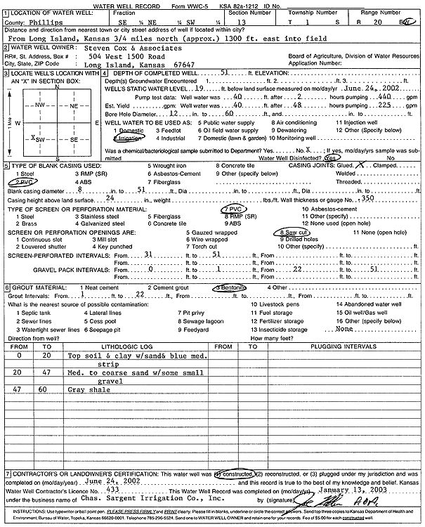
Specific Water Well Detail |
|
|
| Location Info | |||
| Owner: Steven Cox & Associates | Status: Constructed | ||
| Location: T1S, R20W, Sec. 13, SE NE SW | County: Phillips | ||
| Directions: from Long Island: .75 mi N, 1300 feet into field | |||
| Latitude: 39.9631764 | Longitude: -99.5255967 | Datum NAD 27 | |
| Latitude: 39.9631858 | Longitude: -99.5259795 | Datum NAD 83 | |
| Longitude and latitude calculated by Survey from township-range-section-quarter calls. Only good to within the quarter call accuracy. | |||
| View well on interactive map | |||
| General Info | ||
| Well Depth: 51 ft. | Elevation: ft. | |
| Static Water Level: 19 ft. | Est. Yield: gpm. | |
| Comp. Date: 24-Jun-2002 | Well Use: Irrigation | |
| DWR Applic. #: | Other ID: | |
| Links | |
| No Wizard information available. | |
| View info from WIMAS Water Right Data base... | |
| Driller Info | ||
| Driller: Chas. Sargent Irrigation Co., Inc. | License #: 433 | |
| Scanned Form | View scan |
|
Chemical Sample Submitted?:
Water Well disinfected?: | ||
| Casing Info | ||
| Casing Type:
Casing Joints: |
Diam: in. to ft | |
| Casing height above land surface: in
Casing Weight: lbs/ft Wall thickness or gauge no.: | ||
| Screen and Perforation Info | ||
| Screen Type: | Screen Openings: | |
| Screen-perforated intervals | From: ft to ft | |
| Gravel pack intervals | From: ft to ft | |
| Grout Info | ||
| Grout used: | From: to ft | |
| Source of Possible Contamination | ||
| Source: | ||
| Direction from well: | Distance: ft | |
| Lithologic Log
(Log data entered by KGS.) | ||
| From: 0 ft. to 20 ft. | topsoil and clay with sand and blue medium strip | |
| From: 20 ft. to 47 ft. | medium to coarse sand with some small gravel | |
| From: 47 ft. to 60 ft. | gray shale | |