|
|
|
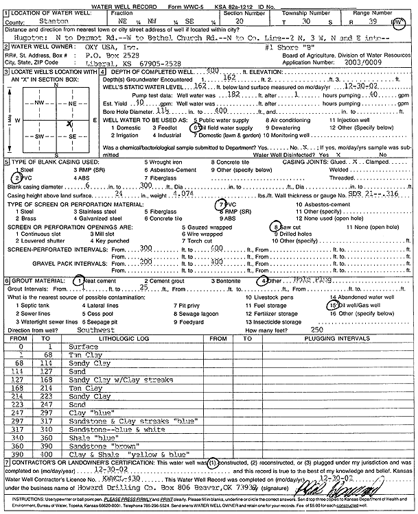
Specific Water Well Detail |
|
|
| Location Info | |||
| Owner: Oxy USA, Inc. | Status: Constructed | ||
| Location: T30S, R39W, Sec. 20, NE NW SE | County: Stanton | ||
| Directions: from Hugoton: N to Dermot Rd, W to Bethel Church Rd, N to Co Line, 2 mi N, 3 mi W, N and E | |||
| Latitude: 37.4238901 | Longitude: -101.6040216 | Datum NAD 27 | |
| Latitude: 37.4239112 | Longitude: -101.6044659 | Datum NAD 83 | |
| Longitude and latitude calculated by Survey from township-range-section-quarter calls. Only good to within the quarter call accuracy. | |||
| View well on interactive map | |||
| General Info | ||
| Well Depth: 400 ft. | Elevation: ft. | |
| Static Water Level: 162 ft. | Est. Yield: 40 gpm. | |
| Comp. Date: 30-Dec-2002 | Well Use: Oil Field Water Supply | |
| DWR Applic. #: 20030009 | Other ID: Shore B-1 | |
| Links | |
| No Wizard information available. | |
| View info from WIMAS Water Right Data base... | |
| Driller Info | ||
| Driller: Howard Drilling Company AG, LLC | License #: 430 | |
| Scanned Form | View scan |
|
Chemical Sample Submitted?:
Water Well disinfected?: | ||
| Casing Info | ||
| Casing Type:
Casing Joints: |
Diam: in. to ft | |
| Casing height above land surface: in
Casing Weight: lbs/ft Wall thickness or gauge no.: | ||
| Screen and Perforation Info | ||
| Screen Type: | Screen Openings: | |
| Screen-perforated intervals | From: ft to ft | |
| Gravel pack intervals | From: ft to ft | |
| Grout Info | ||
| Grout used: | From: to ft | |
| Source of Possible Contamination | ||
| Source: | ||
| Direction from well: | Distance: ft | |
| Lithologic Log
(Log data entered by KGS.) | ||
| From: 0 ft. to 1 ft. | surface | |
| From: 1 ft. to 68 ft. | tan clay | |
| From: 68 ft. to 114 ft. | sandy clay | |
| From: 114 ft. to 127 ft. | sand | |
| From: 127 ft. to 168 ft. | sandy clay with clay streaks | |
| From: 168 ft. to 214 ft. | tan clay | |
| From: 214 ft. to 223 ft. | sandy clay | |
| From: 223 ft. to 247 ft. | sand | |
| From: 247 ft. to 297 ft. | clay, blue | |
| From: 297 ft. to 317 ft. | sandstone and clay streaks, blue | |
| From: 317 ft. to 340 ft. | sandstone - blue and white | |
| From: 340 ft. to 360 ft. | shale, blue | |
| From: 360 ft. to 390 ft. | sandstone, brown | |
| From: 390 ft. to 400 ft. | clay and shale, yellow and blue | |