|
|
|
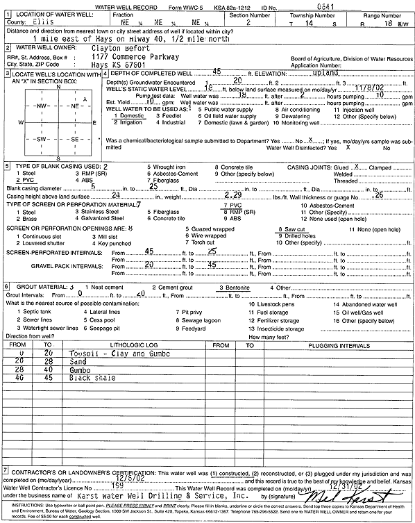
Specific Water Well Detail |
|
|
| Location Info | |||
| Owner: Befort, Clayton | Status: Constructed | ||
| Location: T14S, R18W, Sec. 2, NE NE NE | County: Ellis | ||
| Directions: from Hays: 1 mi E on Hwy 40, .5 mi N | |||
| Latitude: 38.8700635 | Longitude: -99.2815541 | Datum NAD 27 | |
| Latitude: 38.8700753 | Longitude: -99.2819339 | Datum NAD 83 | |
| Longitude and latitude calculated by Survey from township-range-section-quarter calls. Only good to within the quarter call accuracy. | |||
| View well on interactive map | |||
| General Info | ||
| Well Depth: 45 ft. | Elevation: ft. | |
| Static Water Level: 18 ft. | Est. Yield: 10 gpm. | |
| Comp. Date: 06-Dec-2002 | Well Use: Domestic | |
| DWR Applic. #: | Other ID: | |
| Driller Info | ||
| Driller: Karst Water Well Drilling & Service, Inc. | License #: 199 | |
| Scanned Form | View scan |
|
Chemical Sample Submitted?:
Water Well disinfected?: | ||
| Casing Info | ||
| Casing Type:
Casing Joints: |
Diam: in. to ft | |
| Casing height above land surface: in
Casing Weight: lbs/ft Wall thickness or gauge no.: | ||
| Screen and Perforation Info | ||
| Screen Type: | Screen Openings: | |
| Screen-perforated intervals | From: ft to ft | |
| Gravel pack intervals | From: ft to ft | |
| Grout Info | ||
| Grout used: | From: to ft | |
| Source of Possible Contamination | ||
| Source: | ||
| Direction from well: | Distance: ft | |
| Lithologic Log
(Log data entered by KGS.) | ||
| From: 0 ft. to 20 ft. | top soil, clay, and gumbo | |
| From: 20 ft. to 28 ft. | sand | |
| From: 28 ft. to 40 ft. | gumbo | |
| From: 40 ft. to 45 ft. | black shale | |