|
|
|
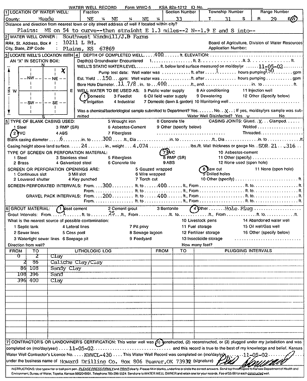
Specific Water Well Detail |
|
|
| Location Info | |||
| Owner: Southwest Windmill/J.B. Farms | Status: Constructed | ||
| Location: T31S, R29W, Sec. 33, NE NE NE | County: Meade | ||
| Directions: from Plains: NE on 54 to curve, 1.3 mi E, 2 mi N, 1.9 mi E, and S into site | |||
| Latitude: 37.3138855 | Longitude: -100.4719061 | Datum NAD 27 | |
| Latitude: 37.3139086 | Longitude: -100.4723335 | Datum NAD 83 | |
| Longitude and latitude calculated by Survey from township-range-section-quarter calls. Only good to within the quarter call accuracy. | |||
| View well on interactive map | |||
| General Info | ||
| Well Depth: 400 ft. | Elevation: ft. | |
| Static Water Level: ft. | Est. Yield: 150 gpm. | |
| Comp. Date: 05-Nov-2002 | Well Use: Domestic | |
| DWR Applic. #: | Other ID: | |
| Driller Info | ||
| Driller: Howard Drilling Company AG, LLC | License #: 430 | |
| Scanned Form | View scan |
|
Chemical Sample Submitted?:
Water Well disinfected?: | ||
| Casing Info | ||
| Casing Type:
Casing Joints: |
Diam: in. to ft | |
| Casing height above land surface: in
Casing Weight: lbs/ft Wall thickness or gauge no.: | ||
| Screen and Perforation Info | ||
| Screen Type: | Screen Openings: | |
| Screen-perforated intervals | From: ft to ft | |
| Gravel pack intervals | From: ft to ft | |
| Grout Info | ||
| Grout used: | From: to ft | |
| Source of Possible Contamination | ||
| Source: | ||
| Direction from well: | Distance: ft | |
| Lithologic Log
(Log data entered by KGS.) | ||
| From: 0 ft. to 2 ft. | clay | |
| From: 2 ft. to 86 ft. | caliche clay and clay | |
| From: 86 ft. to 108 ft. | sandy clay | |
| From: 108 ft. to 396 ft. | sand | |
| From: 396 ft. to 400 ft. | clay | |