|
|
|
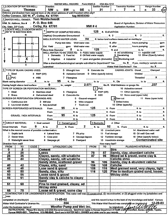
Specific Water Well Detail |
|
|
| Location Info | |||
| Owner: Waldschmidt, Tom | Status: Constructed | ||
| Location: T7S, R33W, Sec. 31, NW SW SE | County: Thomas | ||
| Directions: 320 W 4th, Colby (Tag 00353360) | |||
| Latitude: 39.3970264 | Longitude: -101.0439917 | Datum NAD 27 | |
| Latitude: 39.3970301 | Longitude: -101.0444245 | Datum NAD 83 | |
| Longitude and latitude calculated by Survey from township-range-section-quarter calls. Only good to within the quarter call accuracy. | |||
| View well on interactive map | |||
| General Info | ||
| Well Depth: 125 ft. | Elevation: ft. | |
| Static Water Level: ft. | Est. Yield: gpm. | |
| Comp. Date: 05-Nov-2002 | Well Use: Monitoring well/observation/piezometer | |
| DWR Applic. #: | Other ID: MW 4 | |
| Driller Info | ||
| Driller: Jay C. Woofter Pump & Well, Inc. | License #: 554 | |
| Scanned Form | View scan |
|
Chemical Sample Submitted?:
Water Well disinfected?: | ||
| Casing Info | ||
| Casing Type:
Casing Joints: |
Diam: in. to ft | |
| Casing height above land surface: in
Casing Weight: lbs/ft Wall thickness or gauge no.: | ||
| Screen and Perforation Info | ||
| Screen Type: | Screen Openings: | |
| Screen-perforated intervals | From: ft to ft | |
| Gravel pack intervals | From: ft to ft | |
| Grout Info | ||
| Grout used: | From: to ft | |
| Source of Possible Contamination | ||
| Source: | ||
| Direction from well: | Distance: ft | |
| Lithologic Log
(Log data entered by KGS.) | ||
| From: 0 ft. to .5 ft. | Cement | |
| From: .5 ft. to 26 ft. | Loess | |
| From: 26 ft. to 36 ft. | Clayey, sandy, silt with caliche | |
| From: 36 ft. to 40 ft. | Clayey, sandy, silt with caliche sandy streaks, scattered gravel | |
| From: 40 ft. to 42 ft. | Clayey, silty, sand | |
| From: 42 ft. to 45 ft. | Lose sand and gravel | |
| From: 45 ft. to 50 ft. | Sandy, clay, silty | |
| From: 50 ft. to 56 ft. | Loose sand and gravel | |
| From: 56 ft. to 61 ft. | Sandy clay and caliche to clayey sand | |
| From: 61 ft. to 68 ft. | Fine to medium grained, clayey, sand with clay streaks | |
| From: 68 ft. to 78 ft. | Loose sand and gravel, some clay streaks | |
| From: 78 ft. to 87 ft. | Sandy, clay, abundant caliche | |
| From: 87 ft. to 96 ft. | Mixed sand and gravel, some clay and caliche streaks | |
| From: 96 ft. to 106 ft. | Sandy, clay and abundant caliche | |
| From: 106 ft. to 108 ft. | Caliche | |
| From: 108 ft. to 116 ft. | Medium grained sand, very clayey, tight | |
| From: 116 ft. to 125 ft. | Fine to medium grained sand, looser, with clay streaks | |