|
|
|
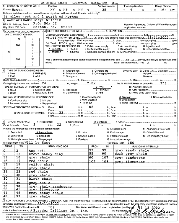
Specific Water Well Detail |
|
|
| Location Info | |||
| Owner: Wilhelm, Daryl | Status: Constructed | ||
| Location: T4S, R16E, Sec. 25, NW NE NW | County: Brown | ||
| Directions: from Horton: 1.5 mi W, 1 mi N | |||
| Latitude: 39.6809304 | Longitude: -95.5766544 | Datum NAD 27 | |
| Latitude: 39.6809316 | Longitude: -95.5769137 | Datum NAD 83 | |
| Longitude and latitude calculated by Survey from township-range-section-quarter calls. Only good to within the quarter call accuracy. | |||
| View well on interactive map | |||
| General Info | ||
| Well Depth: 110 ft. | Elevation: ft. | |
| Static Water Level: 54 ft. | Est. Yield: 6.5 gpm. | |
| Comp. Date: 11-Nov-2002 | Well Use: Domestic | |
| DWR Applic. #: | Other ID: | |
| Driller Info | ||
| Driller: Strader Drilling Co., Inc. | License #: 182 | |
| Scanned Form | View scan |
|
Chemical Sample Submitted?:
Water Well disinfected?: | ||
| Casing Info | ||
| Casing Type:
Casing Joints: |
Diam: in. to ft | |
| Casing height above land surface: in
Casing Weight: lbs/ft Wall thickness or gauge no.: | ||
| Screen and Perforation Info | ||
| Screen Type: | Screen Openings: | |
| Screen-perforated intervals | From: ft to ft | |
| Gravel pack intervals | From: ft to ft | |
| Grout Info | ||
| Grout used: | From: to ft | |
| Source of Possible Contamination | ||
| Source: | ||
| Direction from well: | Distance: ft | |
| Lithologic Log
(Log data entered by KGS.) | ||
| From: 0 ft. to 2 ft. | Topsoil | |
| From: 2 ft. to 13 ft. | Brown sandy clay | |
| From: 13 ft. to 16 ft. | Gray shale | |
| From: 16 ft. to 17 ft. | Red shale | |
| From: 17 ft. to 18 ft. | Yellow shale | |
| From: 18 ft. to 21 ft. | Gray shale | |
| From: 21 ft. to 22 ft. | Red shale | |
| From: 22 ft. to 30 ft. | Gray shale | |
| From: 30 ft. to 31 ft. | Black shale | |
| From: 31 ft. to 36 ft. | Gray shale | |
| From: 36 ft. to 38 ft. | Gray shaley sandstone | |
| From: 38 ft. to 41 ft. | Gray limestone | |
| From: 41 ft. to 48 ft. | Gray sandy clay | |
| From: 48 ft. to 53 ft. | Gray shale | |
| From: 53 ft. to 55 ft. | Gray sandy shale | |
| From: 55 ft. to 60 ft. | Dark gray shale | |
| From: 60 ft. to 107 ft. | Gray sandstone | |
| From: 107 ft. to 108 ft. | Gray limestone | |