|
|
|
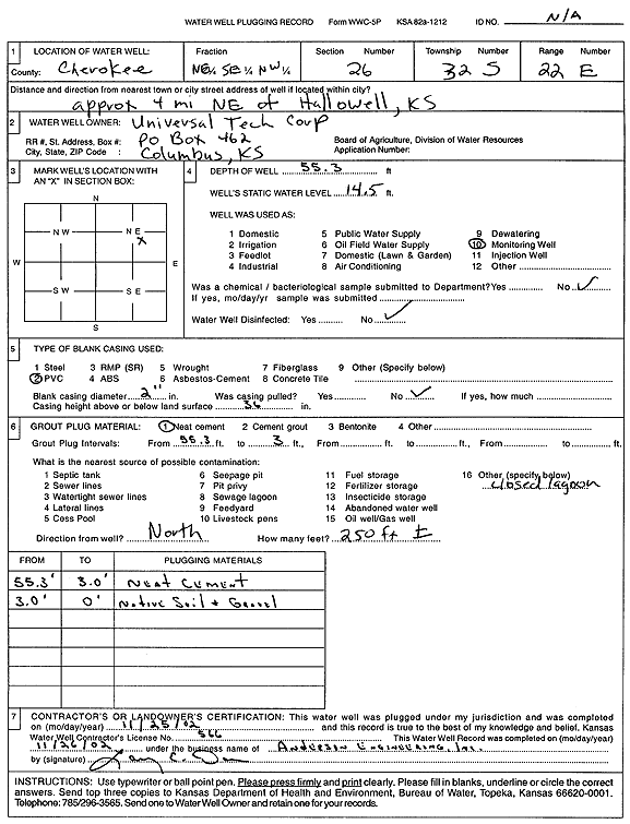
Specific Water Well Detail |
|
|
| Location Info | |||
| Owner: Universal Tech Corp | Status: Plugged | ||
| Location: T32S, R22E, Sec. 26, NE SE NW | County: Cherokee | ||
| Directions: from Hallowell: 4 mi NE | |||
| Latitude: 37.2330222 | Longitude: -94.9689611 | Datum NAD 27 | |
| Latitude: 37.2330831 | Longitude: -94.9692012 | Datum NAD 83 | |
| Longitude and latitude calculated by Survey from township-range-section-quarter calls. Only good to within the quarter call accuracy. | |||
| View well on interactive map | |||
| General Info | ||
| Well Depth: 55.3 ft. | Elevation: ft. | |
| Static Water Level: 14.5 ft. | Est. Yield: gpm. | |
| Comp. Date: 25-Nov-2002 | Well Use: Monitoring well/observation/piezometer | |
| DWR Applic. #: | Other ID: | |
| Driller Info | ||
| Driller: Anderson Engineering, Inc. | License #: 566 | |
| Scanned Form | View scan |
| Casing Info | ||
|
Casing Type:
Diam: in. Casing height above land surface: in | ||
| Grout Info | ||
| Grout used: | From: to ft | |
| Source of Possible Contamination | ||
| Source: | ||
| Direction from well: | Distance: ft | |