|
|
|
Specific Water Well Detail |
|
|
| Location Info | |||
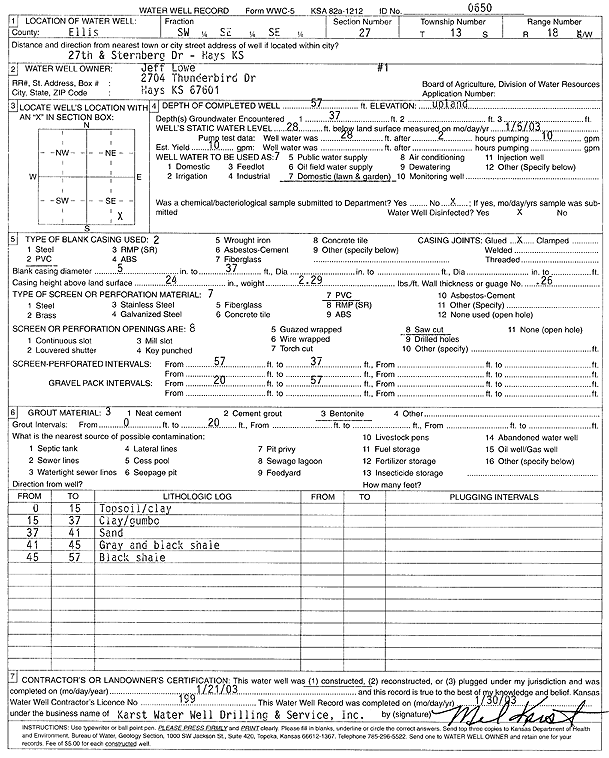
| Owner: Lowe, Jeff | Status: Constructed | ||
| Location: T13S, R18W, Sec. 27, SW SE SE | County: Ellis | ||
| Directions: 27th and Sternberg Dr, Hays | |||
| Latitude: 38.886383 | Longitude: -99.3023263 | Datum NAD 27 | |
| Latitude: 38.8863946 | Longitude: -99.3027068 | Datum NAD 83 | |
| Longitude and latitude calculated by Survey from township-range-section-quarter calls. Only good to within the quarter call accuracy. | |||
| View well on interactive map | |||
| General Info | ||
| Well Depth: 57 ft. | Elevation: ft. | |
| Static Water Level: 28 ft. | Est. Yield: 10 gpm. | |
| Comp. Date: 21-Jan-2003 | Well Use: Domestic, Lawn and Garden | |
| DWR Applic. #: | Other ID: 1 | |
| Driller Info | ||
| Driller: Karst Water Well Drilling & Service, Inc. | License #: 199 | |
| Scanned Form | View scan |
|
Chemical Sample Submitted?:
Water Well disinfected?: | ||
| Casing Info | ||
| Casing Type:
Casing Joints: |
Diam: in. to ft | |
| Casing height above land surface: in
Casing Weight: lbs/ft Wall thickness or gauge no.: | ||
| Screen and Perforation Info | ||
| Screen Type: | Screen Openings: | |
| Screen-perforated intervals | From: ft to ft | |
| Gravel pack intervals | From: ft to ft | |
| Grout Info | ||
| Grout used: | From: to ft | |
| Source of Possible Contamination | ||
| Source: | ||
| Direction from well: | Distance: ft | |
| Lithologic Log
(Log data entered by KGS.) | ||
| From: 0 ft. to 15 ft. | top soil and clay | |
| From: 15 ft. to 37 ft. | clay and gumbo | |
| From: 37 ft. to 41 ft. | sand | |
| From: 41 ft. to 45 ft. | gray and black shale | |
| From: 45 ft. to 57 ft. | black shale | |