|
|
|
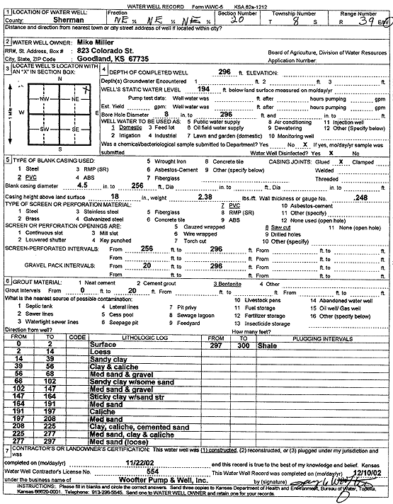
Specific Water Well Detail |
|
|
| Location Info | |||
| Owner: Miller, Mike | Status: Constructed | ||
| Location: T8S, R39W, Sec. 20, NE NE NE | County: Sherman | ||
| Directions: | |||
| Latitude: 39.3503217 | Longitude: -101.6891781 | Datum NAD 27 | |
| Latitude: 39.3503216 | Longitude: -101.6896275 | Datum NAD 83 | |
| Longitude and latitude calculated by Survey from township-range-section-quarter calls. Only good to within the quarter call accuracy. | |||
| View well on interactive map | |||
| General Info | ||
| Well Depth: 296 ft. | Elevation: ft. | |
| Static Water Level: 194 ft. | Est. Yield: gpm. | |
| Comp. Date: 22-Nov-2002 | Well Use: Domestic | |
| DWR Applic. #: | Other ID: | |
| Driller Info | ||
| Driller: Jay C. Woofter Pump & Well, Inc. | License #: 554 | |
| Scanned Form | View scan |
|
Chemical Sample Submitted?:
Water Well disinfected?: | ||
| Casing Info | ||
| Casing Type:
Casing Joints: |
Diam: in. to ft | |
| Casing height above land surface: in
Casing Weight: lbs/ft Wall thickness or gauge no.: | ||
| Screen and Perforation Info | ||
| Screen Type: | Screen Openings: | |
| Screen-perforated intervals | From: ft to ft | |
| Gravel pack intervals | From: ft to ft | |
| Grout Info | ||
| Grout used: | From: to ft | |
| Source of Possible Contamination | ||
| Source: | ||
| Direction from well: | Distance: ft | |
| Lithologic Log
(Log data entered by KGS.) | ||
| From: 0 ft. to 2 ft. | Surface | |
| From: 2 ft. to 14 ft. | Loess | |
| From: 14 ft. to 39 ft. | Sandy clay | |
| From: 39 ft. to 56 ft. | Clay and caliche | |
| From: 56 ft. to 68 ft. | Medium sand and gravel | |
| From: 68 ft. to 102 ft. | Sandy clay with some sand | |
| From: 102 ft. to 147 ft. | Medium sand and gravel | |
| From: 147 ft. to 164 ft. | Sticky clay with sand streak | |
| From: 164 ft. to 191 ft. | Medium sand | |
| From: 191 ft. to 197 ft. | Caliche | |
| From: 197 ft. to 208 ft. | Medium sand | |
| From: 208 ft. to 225 ft. | Clay, caliche, cemented sand | |
| From: 225 ft. to 277 ft. | Medium sand, clay, and caliche | |
| From: 277 ft. to 297 ft. | Medium sand, loose | |
| From: 297 ft. to 300 ft. | Shale | |