|
|
|
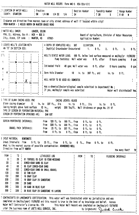
Specific Water Well Detail |
|
|
| Location Info | |||
| Owner: Loader, Delon | Status: Constructed | ||
| Location: T28S, R42W, Sec. 34, SW NW SE | County: Stanton | ||
| Directions: from Manter, 3 mi N on Manter Grade Road | |||
| Latitude: 37.5682283 | Longitude: -101.8961875 | Datum NAD 27 | |
| Latitude: 37.5682445 | Longitude: -101.89664 | Datum NAD 83 | |
| Longitude and latitude calculated by Survey from township-range-section-quarter calls. Only good to within the quarter call accuracy. | |||
| View well on interactive map | |||
| General Info | ||
| Well Depth: 307 ft. | Elevation: ft. | |
| Static Water Level: 188 ft. | Est. Yield: 40 gpm. | |
| Comp. Date: 06-Nov-2002 | Well Use: Domestic | |
| DWR Applic. #: | Other ID: | |
| Driller Info | ||
| Driller: Joe's Well Service, Inc. | License #: 179 | |
| Scanned Form | View scan |
|
Chemical Sample Submitted?:
Water Well disinfected?: | ||
| Casing Info | ||
| Casing Type:
Casing Joints: |
Diam: in. to ft | |
| Casing height above land surface: in
Casing Weight: lbs/ft Wall thickness or gauge no.: | ||
| Screen and Perforation Info | ||
| Screen Type: | Screen Openings: | |
| Screen-perforated intervals | From: ft to ft | |
| Gravel pack intervals | From: ft to ft | |
| Grout Info | ||
| Grout used: | From: to ft | |
| Source of Possible Contamination | ||
| Source: | ||
| Direction from well: | Distance: ft | |
| Lithologic Log
(Log data entered by KGS.) | ||
| From: 0 ft. to 20 ft. | topsoil clay fine-medium sand | |
| From: 20 ft. to 40 ft. | medium-coarse sand clay | |
| From: 40 ft. to 60 ft. | clay medium-coarse sand | |
| From: 60 ft. to 130 ft. | medium-coarse sand small gravel | |
| From: 130 ft. to 150 ft. | tan clay | |
| From: 150 ft. to 200 ft. | gray clay | |
| From: 200 ft. to 220 ft. | gray clay sandstone | |
| From: 220 ft. to 280 ft. | sand | |
| From: 280 ft. to 300 ft. | sand blue clay | |
| From: 300 ft. to 320 ft. | blue clay sandstone layers | |