|
|
|
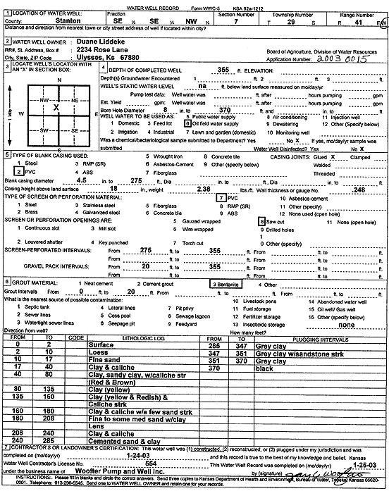
Specific Water Well Detail |
|
|
| Location Info | |||
| Owner: Liddeke, Duane | Status: Constructed | ||
| Location: T29S, R41W, Sec. 7, SE SE NW | County: Stanton | ||
| Directions: | |||
| Latitude: 37.5424862 | Longitude: -101.8441875 | Datum NAD 27 | |
| Latitude: 37.5425032 | Longitude: -101.8446386 | Datum NAD 83 | |
| Longitude and latitude calculated by Survey from township-range-section-quarter calls. Only good to within the quarter call accuracy. | |||
| View well on interactive map | |||
| General Info | ||
| Well Depth: 355 ft. | Elevation: ft. | |
| Static Water Level: ft. | Est. Yield: gpm. | |
| Comp. Date: 24-Jan-2003 | Well Use: Oil Field Water Supply | |
| DWR Applic. #: 20030015 | Other ID: | |
| Links | |
| No Wizard information available. | |
| View info from WIMAS Water Right Data base... | |
| Driller Info | ||
| Driller: Jay C. Woofter Pump & Well, Inc. | License #: 554 | |
| Scanned Form | View scan |
|
Chemical Sample Submitted?:
Water Well disinfected?: | ||
| Casing Info | ||
| Casing Type:
Casing Joints: |
Diam: in. to ft | |
| Casing height above land surface: in
Casing Weight: lbs/ft Wall thickness or gauge no.: | ||
| Screen and Perforation Info | ||
| Screen Type: | Screen Openings: | |
| Screen-perforated intervals | From: ft to ft | |
| Gravel pack intervals | From: ft to ft | |
| Grout Info | ||
| Grout used: | From: to ft | |
| Source of Possible Contamination | ||
| Source: | ||
| Direction from well: | Distance: ft | |
| Lithologic Log
(Log data entered by KGS.) | ||
| From: 0 ft. to 2 ft. | surface | |
| From: 2 ft. to 10 ft. | loess | |
| From: 10 ft. to 17 ft. | fine sand | |
| From: 17 ft. to 40 ft. | clay and caliche | |
| From: 40 ft. to 80 ft. | clay, sandy clay, with caliche streak (red and brown) | |
| From: 80 ft. to 135 ft. | clay (yellow) | |
| From: 135 ft. to 160 ft. | clay (yellow and reddish) and caliche streak | |
| From: 160 ft. to 180 ft. | clay and caliche with a few sand streak | |
| From: 180 ft. to 208 ft. | fine to some medium sand with clay lens | |
| From: 208 ft. to 240 ft. | clay and caliche | |
| From: 240 ft. to 285 ft. | cemented sand and clay | |
| From: 285 ft. to 347 ft. | gray clay | |
| From: 347 ft. to 351 ft. | gray clay with sandstone streak | |
| From: 351 ft. to 370 ft. | gray clay | |
| From: 370 ft. to ft. | black | |