|
|
|
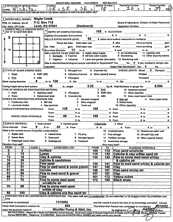
Specific Water Well Detail |
|
|
| Location Info | |||
| Owner: Maple Creek | Status: Constructed | ||
| Location: T20S, R37W, Sec. 18, SE SE SE | County: Wichita | ||
| Directions: | |||
| Latitude: 38.308085 | Longitude: -101.43971 | Datum NAD 27 | |
| Latitude: 38.3081034 | Longitude: -101.4401526 | Datum NAD 83 | |
| Longitude and latitude calculated by Survey from township-range-section-quarter calls. Only good to within the quarter call accuracy. | |||
| View well on interactive map | |||
| General Info | ||
| Well Depth: 168 ft. | Elevation: ft. | |
| Static Water Level: 88 ft. | Est. Yield: gpm. | |
| Comp. Date: 13-Nov-2002 | Well Use: Domestic | |
| DWR Applic. #: | Other ID: | |
| Driller Info | ||
| Driller: Jay C. Woofter Pump & Well, Inc. | License #: 554 | |
| Scanned Form | View scan |
|
Chemical Sample Submitted?:
Water Well disinfected?: | ||
| Casing Info | ||
| Casing Type:
Casing Joints: |
Diam: in. to ft | |
| Casing height above land surface: in
Casing Weight: lbs/ft Wall thickness or gauge no.: | ||
| Screen and Perforation Info | ||
| Screen Type: | Screen Openings: | |
| Screen-perforated intervals | From: ft to ft | |
| Gravel pack intervals | From: ft to ft | |
| Grout Info | ||
| Grout used: | From: to ft | |
| Source of Possible Contamination | ||
| Source: | ||
| Direction from well: | Distance: ft | |
| Lithologic Log
(Log data entered by KGS.) | ||
| From: 0 ft. to 2 ft. | Surface | |
| From: 2 ft. to 13 ft. | Loess | |
| From: 13 ft. to 16 ft. | Clay and caliche | |
| From: 16 ft. to 26 ft. | Caliche and sandstone | |
| From: 26 ft. to 31 ft. | Fine sand | |
| From: 31 ft. to 51 ft. | Fine to medium sand and some gravel | |
| From: 51 ft. to 53 ft. | Caliche | |
| From: 53 ft. to 66 ft. | Fine to medium sand and gravel | |
| From: 66 ft. to 71 ft. | Clay | |
| From: 71 ft. to 76 ft. | Fine to some medium sand with caliche streaks | |
| From: 76 ft. to 88 ft. | Fine to some medium sand with lots of clay | |
| From: 88 ft. to 100 ft. | Clay and caliche with a few sand streaks | |
| From: 100 ft. to 115 ft. | Fine sand with caliche | |
| From: 115 ft. to 120 ft. | Caliche and clay with fine sand streak | |
| From: 120 ft. to 130 ft. | Fine to some medium sand with clay and caliche streak | |
| From: 130 ft. to 141 ft. | Fine to medium sand with clay and caliche lens | |
| From: 141 ft. to 145 ft. | Clay | |
| From: 145 ft. to 157 ft. | Fine sand with clay streaks | |
| From: 157 ft. to 161 ft. | Clay | |
| From: 161 ft. to 172 ft. | Yellow ochre | |
| From: 172 ft. to 180 ft. | Black shale | |