|
|
|
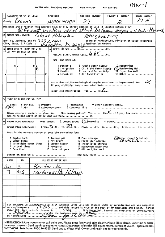
Specific Water Well Detail |
|
|
| Location Info | |||
| Owner: City of Hiawatha | Status: Plugged | ||
| Location: T2S, R17E, Sec. 29, NW SE NE | County: Brown | ||
| Directions: 80 feet East in alley off of 5th St between Oregon & Utah, Hiawatha | |||
| Latitude: 39.851421 | Longitude: -95.530431 | Datum NAD 27 | |
| Latitude: 39.8514244 | Longitude: -95.5306909 | Datum NAD 83 | |
| Longitude and latitude calculated by Survey from township-range-section-quarter calls. Only good to within the quarter call accuracy. | |||
| View well on interactive map | |||
| General Info | ||
| Well Depth: 35 ft. | Elevation: ft. | |
| Static Water Level: 6.65 ft. | Est. Yield: gpm. | |
| Comp. Date: 21-Jan-2003 | Well Use: Monitoring well/observation/piezometer | |
| DWR Applic. #: | Other ID: MW 1 | |
| Driller Info | ||
| Driller: Associated Environmental, Inc. | License #: 585 | |
| Scanned Form | View scan |
| Casing Info | ||
|
Casing Type:
Diam: in. Casing height above land surface: in | ||
| Grout Info | ||
| Grout used: | From: to ft | |
| Source of Possible Contamination | ||
| Source: | ||
| Direction from well: | Distance: ft | |