|
|
|
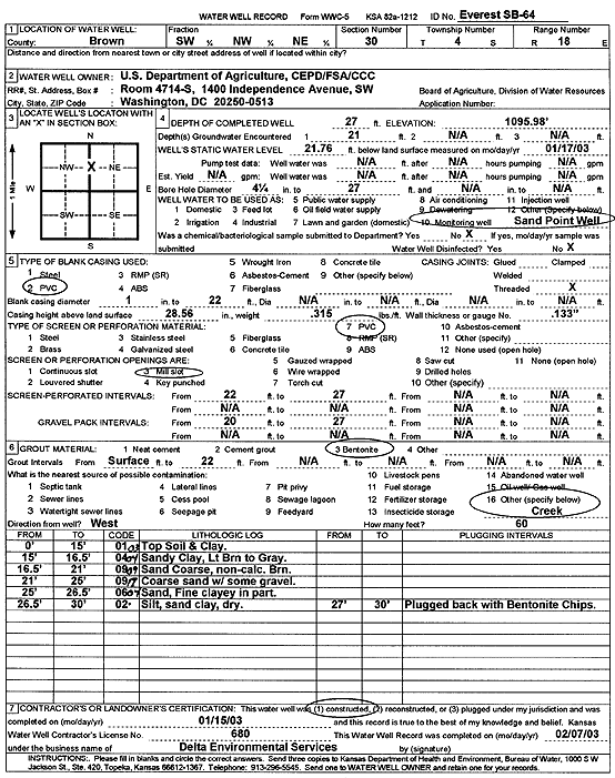
Specific Water Well Detail |
|
|
| Location Info | |||
| Owner: U.S. Dept. of Agriculture | Status: Constructed | ||
| Location: T4S, R18E, Sec. 30, SW NW NE | County: Brown | ||
| Directions: | |||
| Latitude: 39.6791048 | Longitude: -95.4416024 | Datum NAD 27 | |
| Latitude: 39.6791065 | Longitude: -95.4418586 | Datum NAD 83 | |
| Longitude and latitude calculated by Survey from township-range-section-quarter calls. Only good to within the quarter call accuracy. | |||
| View well on interactive map | |||
| General Info | ||
| Well Depth: 27 ft. | Elevation: 1095.98 ft. | |
| Static Water Level: 21.76 ft. | Est. Yield: gpm. | |
| Comp. Date: 15-Jan-2003 | Well Use: Monitoring well/observation/piezometer | |
| DWR Applic. #: | Other ID: SB 64 | |
| Driller Info | ||
| Driller: Delta Environmental | License #: 680 | |
| Scanned Form | View scan |
|
Chemical Sample Submitted?:
Water Well disinfected?: | ||
| Casing Info | ||
| Casing Type:
Casing Joints: |
Diam: in. to ft | |
| Casing height above land surface: in
Casing Weight: lbs/ft Wall thickness or gauge no.: | ||
| Screen and Perforation Info | ||
| Screen Type: | Screen Openings: | |
| Screen-perforated intervals | From: ft to ft | |
| Gravel pack intervals | From: ft to ft | |
| Grout Info | ||
| Grout used: | From: to ft | |
| Source of Possible Contamination | ||
| Source: | ||
| Direction from well: | Distance: ft | |
| Lithologic Log
(Log data entered by KGS.) | ||
| From: 0 ft. to 15 ft. | top soil and clay | |
| From: 15 ft. to 16.5 ft. | sandy clay, light brown to gray | |
| From: 16.5 ft. to 21 ft. | sand, coarse, non calcareous, brown | |
| From: 21 ft. to 26 ft. | coarse sand with some gravel | |
| From: 26 ft. to 26.5 ft. | sand, fine, clayey in part | |
| From: 26.5 ft. to 30 ft. | silt, sandy clay | |