|
|
|
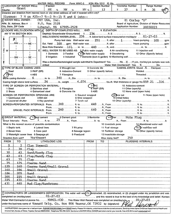
Specific Water Well Detail |
|
|
| Location Info | |||
| Owner: Oxy USA, Inc. | Status: Constructed | ||
| Location: T27S, R36W, Sec. 12, NE NW NW | County: Grant | ||
| Directions: from Ulysses: 7 mi N on 25, 7 mi E, 3 mi N, 1.5 mi E, S into | |||
| Latitude: 37.7206521 | Longitude: -101.2129994 | Datum NAD 27 | |
| Latitude: 37.7206717 | Longitude: -101.2134487 | Datum NAD 83 | |
| Longitude and latitude calculated by Survey from township-range-section-quarter calls. Only good to within the quarter call accuracy. | |||
| View well on interactive map | |||
| General Info | ||
| Well Depth: 440 ft. | Elevation: ft. | |
| Static Water Level: 236 ft. | Est. Yield: 100 gpm. | |
| Comp. Date: 27-Jan-2003 | Well Use: Oil Field Water Supply | |
| DWR Applic. #: 20030023 | Other ID: Corley D 1 | |
| Driller Info | ||
| Driller: Howard Drilling Company AG, LLC | License #: 430 | |
| Scanned Form | View scan |
|
Chemical Sample Submitted?:
Water Well disinfected?: | ||
| Casing Info | ||
| Casing Type:
Casing Joints: |
Diam: in. to ft | |
| Casing height above land surface: in
Casing Weight: lbs/ft Wall thickness or gauge no.: | ||
| Screen and Perforation Info | ||
| Screen Type: | Screen Openings: | |
| Screen-perforated intervals | From: ft to ft | |
| Gravel pack intervals | From: ft to ft | |
| Grout Info | ||
| Grout used: | From: to ft | |
| Source of Possible Contamination | ||
| Source: | ||
| Direction from well: | Distance: ft | |
| Lithologic Log
(Log data entered by KGS.) | ||
| From: 0 ft. to 2 ft. | Clay Topsoil | |
| From: 2 ft. to 30 ft. | Clay | |
| From: 30 ft. to 42 ft. | Sand/Sandy Clay | |
| From: 42 ft. to 63 ft. | Clay/Sandy Clay | |
| From: 63 ft. to 75 ft. | Clay | |
| From: 75 ft. to 125 ft. | Coarse Sand | |
| From: 125 ft. to 160 ft. | Coarse Sand/Small Gravel | |
| From: 160 ft. to 186 ft. | Small Gravel | |
| From: 186 ft. to 205 ft. | Sand | |
| From: 205 ft. to 225 ft. | Small Gravel | |
| From: 225 ft. to 431 ft. | Coarse Sand | |
| From: 431 ft. to 440 ft. | Red Clay/Sandstone | |