|
|
|
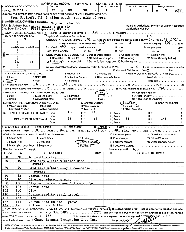
Specific Water Well Detail |
|
|
| Location Info | |||
| Owner: Taylor Swine LLC | Status: Constructed | ||
| Location: T2S, R19W, Sec. 1, SE NW SW | County: Phillips | ||
| Directions: from Woodruff: 6 mi S, E side of rd | |||
| Latitude: 39.9052908 | Longitude: -99.4178504 | Datum NAD 27 | |
| Latitude: 39.9053007 | Longitude: -99.4182285 | Datum NAD 83 | |
| Longitude and latitude calculated by Survey from township-range-section-quarter calls. Only good to within the quarter call accuracy. | |||
| View well on interactive map | |||
| General Info | ||
| Well Depth: 148 ft. | Elevation: ft. | |
| Static Water Level: 101 ft. | Est. Yield: 400 gpm. | |
| Comp. Date: 30-Jan-2003 | Well Use: Irrigation | |
| DWR Applic. #: | Other ID: | |
| Links | |
| No Wizard information available. | |
| View info from WIMAS Water Right Data base... | |
| Driller Info | ||
| Driller: Chas. Sargent Irrigation Co., Inc. | License #: 433 | |
| Scanned Form | View scan |
|
Chemical Sample Submitted?:
Water Well disinfected?: | ||
| Casing Info | ||
| Casing Type:
Casing Joints: |
Diam: in. to ft | |
| Casing height above land surface: in
Casing Weight: lbs/ft Wall thickness or gauge no.: | ||
| Screen and Perforation Info | ||
| Screen Type: | Screen Openings: | |
| Screen-perforated intervals | From: ft to ft | |
| Gravel pack intervals | From: ft to ft | |
| Grout Info | ||
| Grout used: | From: to ft | |
| Source of Possible Contamination | ||
| Source: | ||
| Direction from well: | Distance: ft | |
| Lithologic Log
(Log data entered by KGS.) | ||
| From: 0 ft. to 20 ft. | topsoil and clay | |
| From: 20 ft. to 40 ft. | hard clay and lime with coarse sand strips | |
| From: 40 ft. to 60 ft. | hard lime with thin clay and sandstone strips | |
| From: 60 ft. to 65 ft. | coarse sand | |
| From: 65 ft. to 80 ft. | clay with sandstone strips | |
| From: 80 ft. to 100 ft. | clay with thin sandstone and lime strips | |
| From: 100 ft. to 105 ft. | coarse sand | |
| From: 105 ft. to 110 ft. | clay | |
| From: 110 ft. to 135 ft. | coarse sand to small gravel | |
| From: 135 ft. to 137 ft. | clay | |
| From: 137 ft. to 144 ft. | coarse sand to small gravel | |
| From: 144 ft. to 148 ft. | yellow ochre and lime | |