|
|
|
Specific Water Well Detail |
|
|
| Location Info | |||
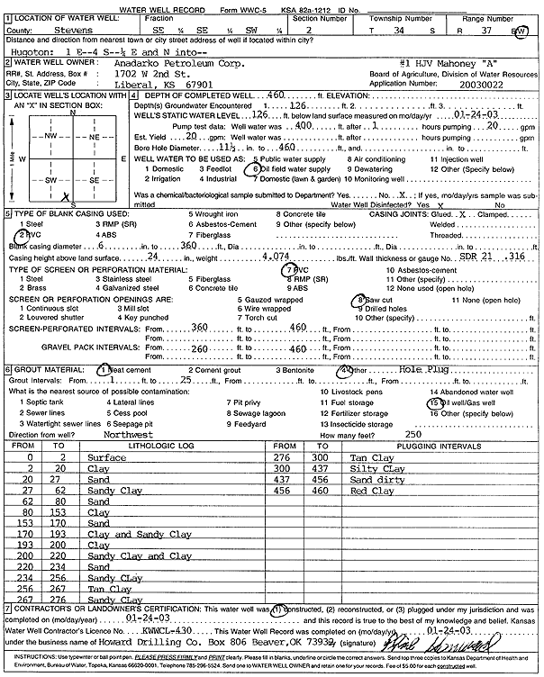
| Owner: Anadarko Petroleum Corp. | Status: Constructed | ||
| Location: T34S, R37W, Sec. 2, SE SE SW | County: Stevens | ||
| Directions: from Hugoton: 1 mi E, 4 mi S, 0.25 mi E, and N into site | |||
| Latitude: 37.1128933 | Longitude: -101.3122877 | Datum NAD 27 | |
| Latitude: 37.1129187 | Longitude: -101.3127248 | Datum NAD 83 | |
| Longitude and latitude calculated by Survey from township-range-section-quarter calls. Only good to within the quarter call accuracy. | |||
| View well on interactive map | |||
| General Info | ||
| Well Depth: 460 ft. | Elevation: ft. | |
| Static Water Level: 126 ft. | Est. Yield: 20 gpm. | |
| Comp. Date: 24-Jan-2003 | Well Use: Oil Field Water Supply | |
| DWR Applic. #: 20030022 | Other ID: HJV Mahoney A-1 | |
| Links | |
| No Wizard information available. | |
| View info from WIMAS Water Right Data base... | |
| Driller Info | ||
| Driller: Howard Drilling Company AG, LLC | License #: 430 | |
| Scanned Form | View scan |
|
Chemical Sample Submitted?:
Water Well disinfected?: | ||
| Casing Info | ||
| Casing Type:
Casing Joints: |
Diam: in. to ft | |
| Casing height above land surface: in
Casing Weight: lbs/ft Wall thickness or gauge no.: | ||
| Screen and Perforation Info | ||
| Screen Type: | Screen Openings: | |
| Screen-perforated intervals | From: ft to ft | |
| Gravel pack intervals | From: ft to ft | |
| Grout Info | ||
| Grout used: | From: to ft | |
| Source of Possible Contamination | ||
| Source: | ||
| Direction from well: | Distance: ft | |
| Lithologic Log
(Log data entered by KGS.) | ||
| From: 0 ft. to 2 ft. | surface | |
| From: 2 ft. to 20 ft. | clay | |
| From: 20 ft. to 27 ft. | sand | |
| From: 27 ft. to 62 ft. | sandy clay | |
| From: 62 ft. to 80 ft. | sand | |
| From: 80 ft. to 153 ft. | clay | |
| From: 153 ft. to 170 ft. | sand | |
| From: 170 ft. to 193 ft. | clay and sandy clay | |
| From: 193 ft. to 200 ft. | clay | |
| From: 200 ft. to 220 ft. | sandy clay and clay | |
| From: 220 ft. to 234 ft. | sand | |
| From: 234 ft. to 256 ft. | sandy clay | |
| From: 256 ft. to 267 ft. | tan clay | |
| From: 267 ft. to 276 ft. | sandy clay | |
| From: 276 ft. to 300 ft. | tan clay | |
| From: 300 ft. to 437 ft. | silty clay | |
| From: 437 ft. to 456 ft. | sand dirty | |
| From: 456 ft. to 460 ft. | red clay | |