|
|
|
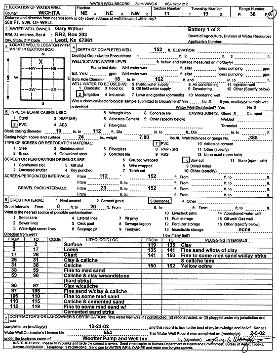
Specific Water Well Detail |
|
|
| Location Info | |||
| Owner: Wilbur, Gary | Status: Constructed | ||
| Location: T19S, R38W, Sec. 11, NE NE NW | County: Wichita | ||
| Directions: 580 ft NW of well | |||
| Latitude: 38.4221269 | Longitude: -101.4857073 | Datum NAD 27 | |
| Latitude: 38.4221441 | Longitude: -101.4861497 | Datum NAD 83 | |
| Longitude and latitude calculated by Survey from township-range-section-quarter calls. Only good to within the quarter call accuracy. | |||
| View well on interactive map | |||
| General Info | ||
| Well Depth: 152 ft. | Elevation: ft. | |
| Static Water Level: ft. | Est. Yield: gpm. | |
| Comp. Date: 23-Dec-2002 | Well Use: Irrigation | |
| DWR Applic. #: | Other ID: battery 1 of 3 | |
| Links | |
| No Wizard information available. | |
| View info from WIMAS Water Right Data base... | |
| Driller Info | ||
| Driller: Jay C. Woofter Pump & Well, Inc. | License #: 554 | |
| Scanned Form | View scan |
|
Chemical Sample Submitted?:
Water Well disinfected?: | ||
| Casing Info | ||
| Casing Type:
Casing Joints: |
Diam: in. to ft | |
| Casing height above land surface: in
Casing Weight: lbs/ft Wall thickness or gauge no.: | ||
| Screen and Perforation Info | ||
| Screen Type: | Screen Openings: | |
| Screen-perforated intervals | From: ft to ft | |
| Gravel pack intervals | From: ft to ft | |
| Grout Info | ||
| Grout used: | From: to ft | |
| Source of Possible Contamination | ||
| Source: | ||
| Direction from well: | Distance: ft | |
| Lithologic Log
(Log data entered by KGS.) | ||
| From: 0 ft. to 2 ft. | Surface | |
| From: 2 ft. to 17 ft. | Loess | |
| From: 17 ft. to 26 ft. | Chert | |
| From: 26 ft. to 31 ft. | Clay and caliche | |
| From: 31 ft. to 38 ft. | Caliche | |
| From: 38 ft. to 59 ft. | Fine to medium sand | |
| From: 59 ft. to 90 ft. | Caliche and clay with sandstone (hard streaks) | |
| From: 90 ft. to 97 ft. | Clay with caliche | |
| From: 97 ft. to 106 ft. | Fine sand with clay and caliche | |
| From: 106 ft. to 110 ft. | Fine to some medium sand | |
| From: 110 ft. to 115 ft. | Caliche and cemented sand | |
| From: 115 ft. to 119 ft. | Fine to some medium sand with cemented sand streaks | |
| From: 119 ft. to 135 ft. | Clay | |
| From: 135 ft. to 141 ft. | Fine sand with lots of clay | |
| From: 141 ft. to 150 ft. | Fine to some medium sand with clay streaks and caliche lens | |
| From: 150 ft. to 162 ft. | Yellow ochre | |