|
|
|
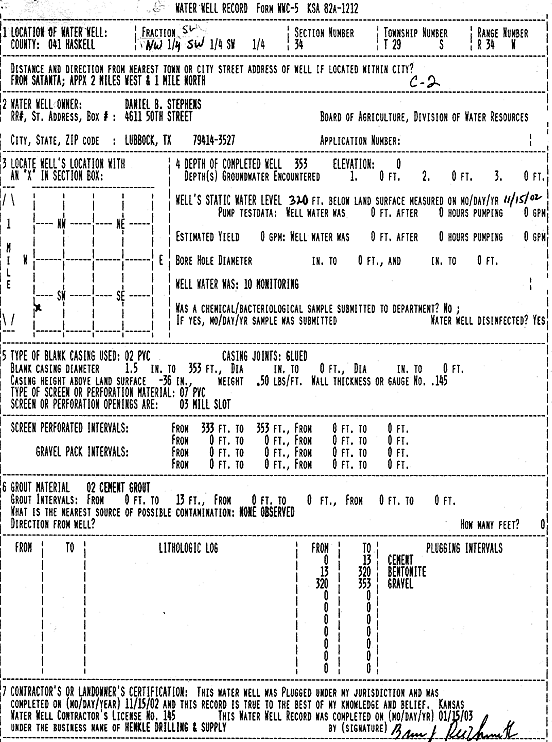
Specific Water Well Detail |
|
|
| Location Info | |||
| Owner: Stephens, Daniel B. | Status: Plugged | ||
| Location: T29S, R34W, Sec. 34, NW SW SW | County: Haskell | ||
| Directions: from Satanta: 2 mi W, 1 mi N | |||
| Latitude: 37.4777657 | Longitude: -101.0333084 | Datum NAD 27 | |
| Latitude: 37.4777903 | Longitude: -101.0337542 | Datum NAD 83 | |
| Longitude and latitude calculated by Survey from township-range-section-quarter calls. Only good to within the quarter call accuracy. | |||
| View well on interactive map | |||
| General Info | ||
| Well Depth: 353 ft. | Elevation: ft. | |
| Static Water Level: 320 ft. | Est. Yield: gpm. | |
| Comp. Date: 15-Nov-2002 | Well Use: Monitoring well/observation/piezometer | |
| DWR Applic. #: | Other ID: MW C-2 | |
| Driller Info | ||
| Driller: Richard Henkle Drilling & Supply Co. Inc. | License #: 145 | |
| Scanned Form | View scan |
| Casing Info | ||
|
Casing Type:
Diam: in. Casing height above land surface: in | ||
| Grout Info | ||
| Grout used: | From: to ft | |
| Source of Possible Contamination | ||
| Source: | ||
| Direction from well: | Distance: ft | |