|
|
|
Specific Water Well Detail |
|
|
| Location Info | |||
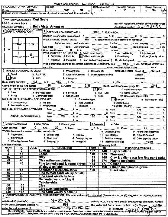
| Owner: Seele, Curt | Status: Constructed | ||
| Location: T11S, R34W, Sec. 2, E2 NW SE | County: Logan | ||
| Directions: | |||
| Latitude: 39.1244344 | Longitude: -101.0587093 | Datum NAD 27 | |
| Latitude: 39.1244418 | Longitude: -101.0591404 | Datum NAD 83 | |
| Longitude and latitude calculated by Survey from township-range-section-quarter calls. Only good to within the quarter call accuracy. | |||
| View well on interactive map | |||
| General Info | ||
| Well Depth: 190 ft. | Elevation: ft. | |
| Static Water Level: ft. | Est. Yield: gpm. | |
| Comp. Date: 05-Mar-2003 | Well Use: Oil Field Water Supply | |
| DWR Applic. #: 20030035 | Other ID: | |
| Links | |
| No Wizard information available. | |
| View info from WIMAS Water Right Data base... | |
| Driller Info | ||
| Driller: Jay C. Woofter Pump & Well, Inc. | License #: 554 | |
| Scanned Form | View scan |
|
Chemical Sample Submitted?:
Water Well disinfected?: | ||
| Casing Info | ||
| Casing Type:
Casing Joints: |
Diam: in. to ft | |
| Casing height above land surface: in
Casing Weight: lbs/ft Wall thickness or gauge no.: | ||
| Screen and Perforation Info | ||
| Screen Type: | Screen Openings: | |
| Screen-perforated intervals | From: ft to ft | |
| Gravel pack intervals | From: ft to ft | |
| Grout Info | ||
| Grout used: | From: to ft | |
| Source of Possible Contamination | ||
| Source: | ||
| Direction from well: | Distance: ft | |
| Lithologic Log
(Log data entered by KGS.) | ||
| From: 0 ft. to 2 ft. | Surface | |
| From: 2 ft. to 15 ft. | Loess | |
| From: 15 ft. to 23 ft. | Clay | |
| From: 23 ft. to 40 ft. | Clay with fine sand streaks | |
| From: 40 ft. to 45 ft. | Fine to medium sand and some gravel with clay and caliche | |
| From: 45 ft. to 55 ft. | Sandstone with caliche streaks | |
| From: 55 ft. to 70 ft. | Fine to medium sand with clay and caliche | |
| From: 70 ft. to 80 ft. | Fine sand with caliche lens | |
| From: 80 ft. to 86 ft. | Cemented sand with clay and caliche streaks | |
| From: 86 ft. to 105 ft. | Clay | |
| From: 105 ft. to 128 ft. | Clay with caliche streaks | |
| From: 128 ft. to 137 ft. | Fine sand with clay and caliche | |
| From: 137 ft. to 148 ft. | Clay and caliche | |
| From: 148 ft. to 153 ft. | Fine sand | |
| From: 153 ft. to 165 ft. | Clay and caliche with a few fine sand streaks | |
| From: 165 ft. to 174 ft. | Fine to medium sand | |
| From: 174 ft. to 177 ft. | Caliche | |
| From: 177 ft. to 198 ft. | Fine to medium sand and gravel | |
| From: 198 ft. to ft. | Black shale | |