|
|
|
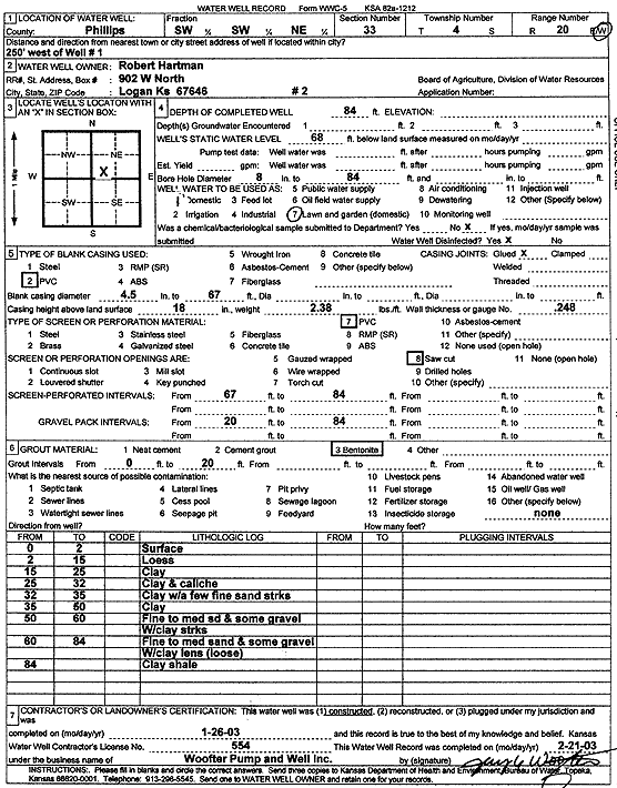
Specific Water Well Detail |
|
|
| Location Info | |||
| Owner: Hartman, Robert | Status: Constructed | ||
| Location: T4S, R20W, Sec. 33, SW SW NE | County: Phillips | ||
| Directions: 250 feet West of well 1 | |||
| Latitude: 39.6625694 | Longitude: -99.5797789 | Datum NAD 27 | |
| Latitude: 39.6625773 | Longitude: -99.5801648 | Datum NAD 83 | |
| Longitude and latitude calculated by Survey from township-range-section-quarter calls. Only good to within the quarter call accuracy. | |||
| View well on interactive map | |||
| General Info | ||
| Well Depth: 84 ft. | Elevation: ft. | |
| Static Water Level: 68 ft. | Est. Yield: gpm. | |
| Comp. Date: 26-Jan-2003 | Well Use: Domestic, Lawn and Garden | |
| DWR Applic. #: | Other ID: Well 2 | |
| Driller Info | ||
| Driller: Jay C. Woofter Pump & Well, Inc. | License #: 554 | |
| Scanned Form | View scan |
|
Chemical Sample Submitted?:
Water Well disinfected?: | ||
| Casing Info | ||
| Casing Type:
Casing Joints: |
Diam: in. to ft | |
| Casing height above land surface: in
Casing Weight: lbs/ft Wall thickness or gauge no.: | ||
| Screen and Perforation Info | ||
| Screen Type: | Screen Openings: | |
| Screen-perforated intervals | From: ft to ft | |
| Gravel pack intervals | From: ft to ft | |
| Grout Info | ||
| Grout used: | From: to ft | |
| Source of Possible Contamination | ||
| Source: | ||
| Direction from well: | Distance: ft | |
| Lithologic Log
(Log data entered by KGS.) | ||
| From: 0 ft. to 2 ft. | surface | |
| From: 2 ft. to 15 ft. | loess | |
| From: 15 ft. to 25 ft. | clay | |
| From: 25 ft. to 32 ft. | clay and caliche | |
| From: 32 ft. to 35 ft. | clay with a few fine sand streaks | |
| From: 35 ft. to 50 ft. | clay | |
| From: 50 ft. to 60 ft. | fine to medium sand and some gravel with clay streaks | |
| From: 60 ft. to 84 ft. | fine to medium sand and some gravel with clay lens, loose | |
| From: 84 ft. to ft. | clay shale | |