|
|
|
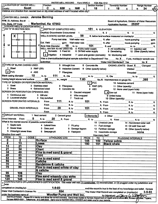
Specific Water Well Detail |
|
|
| Location Info | |||
| Owner: Berning, Jerome | Status: Constructed | ||
| Location: T18S, R34W, Sec. 18, C NW NW | County: Scott | ||
| Directions: | |||
| Latitude: 38.4946544 | Longitude: -101.1250152 | Datum NAD 27 | |
| Latitude: 38.4946744 | Longitude: -101.1254469 | Datum NAD 83 | |
| Longitude and latitude calculated by Survey from township-range-section-quarter calls. Only good to within the quarter call accuracy. | |||
| View well on interactive map | |||
| General Info | ||
| Well Depth: 151 ft. | Elevation: ft. | |
| Static Water Level: 98 ft. | Est. Yield: gpm. | |
| Comp. Date: 09-Jan-2003 | Well Use: Irrigation | |
| DWR Applic. #: 25297 | Other ID: | |
| Links | |
| No Wizard information available. | |
| View info from WIMAS Water Right Data base... | |
| Driller Info | ||
| Driller: Jay C. Woofter Pump & Well, Inc. | License #: 554 | |
| Scanned Form | View scan |
|
Chemical Sample Submitted?:
Water Well disinfected?: | ||
| Casing Info | ||
| Casing Type:
Casing Joints: |
Diam: in. to ft | |
| Casing height above land surface: in
Casing Weight: lbs/ft Wall thickness or gauge no.: | ||
| Screen and Perforation Info | ||
| Screen Type: | Screen Openings: | |
| Screen-perforated intervals | From: ft to ft | |
| Gravel pack intervals | From: ft to ft | |
| Grout Info | ||
| Grout used: | From: to ft | |
| Source of Possible Contamination | ||
| Source: | ||
| Direction from well: | Distance: ft | |
| Lithologic Log
(Log data entered by KGS.) | ||
| From: 0 ft. to 2 ft. | surface | |
| From: 2 ft. to 13 ft. | loess | |
| From: 13 ft. to 21 ft. | clay | |
| From: 21 ft. to 34 ft. | chert | |
| From: 34 ft. to 49 ft. | fine to med sand and gravel | |
| From: 49 ft. to 53 ft. | chert | |
| From: 53 ft. to 59 ft. | fine to med sand | |
| From: 59 ft. to 70 ft. | caliche | |
| From: 70 ft. to 79 ft. | sandstone and caliche | |
| From: 79 ft. to 90 ft. | fine to med sand with lots of clay and caliche | |
| From: 90 ft. to 106 ft. | clay | |
| From: 106 ft. to 120 ft. | fine sand with sandy clay streaks | |
| From: 120 ft. to 145 ft. | fine to med sand and gravel | |
| From: 145 ft. to 150 ft. | yellow ochre | |
| From: 150 ft. to 151 ft. | black shale | |