|
|
|
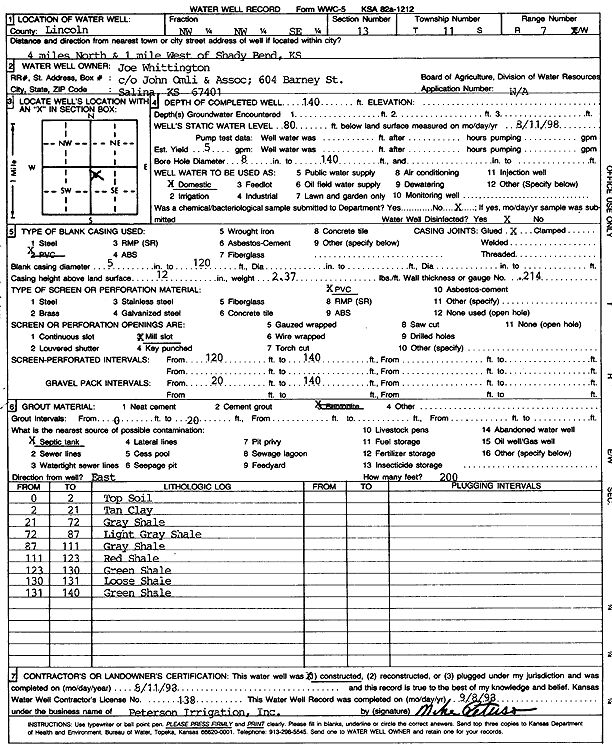
Specific Water Well Detail |
|
|
| Location Info | |||
| Owner: John Omli and Assoc. | Status: Constructed | ||
| Location: T11S, R7W, Sec. 13, NW NW SE | County: Lincoln | ||
| Directions: from Shady Bend, 4 mi N and 1 mi W | |||
| Latitude: 39.0951818 | Longitude: -98.0481657 | Datum NAD 27 | |
| Latitude: 39.095187 | Longitude: -98.0484918 | Datum NAD 83 | |
| Longitude and latitude calculated by Survey from township-range-section-quarter calls. Only good to within the quarter call accuracy. | |||
| View well on interactive map | |||
| General Info | ||
| Well Depth: 140 ft. | Elevation: ft. | |
| Static Water Level: 80 ft. | Est. Yield: 5 gpm. | |
| Comp. Date: 11-Aug-1993 | Well Use: Domestic | |
| DWR Applic. #: | Other ID: | |
| Driller Info | ||
| Driller: Michael Peterson Irrigation, Inc. | License #: 138 | |
| Scanned Form | View scan |
|
Chemical Sample Submitted?:
Water Well disinfected?: | ||
| Casing Info | ||
| Casing Type:
Casing Joints: |
Diam: in. to ft | |
| Casing height above land surface: in
Casing Weight: lbs/ft Wall thickness or gauge no.: | ||
| Screen and Perforation Info | ||
| Screen Type: | Screen Openings: | |
| Screen-perforated intervals | From: ft to ft | |
| Gravel pack intervals | From: ft to ft | |
| Grout Info | ||
| Grout used: | From: to ft | |
| Source of Possible Contamination | ||
| Source: | ||
| Direction from well: | Distance: ft | |
| Lithologic Log
(Log data entered by KGS.) | ||
| From: 0 ft. to 2 ft. | top soil | |
| From: 2 ft. to 21 ft. | tan clay | |
| From: 21 ft. to 72 ft. | gray shale | |
| From: 72 ft. to 87 ft. | light gray shale | |
| From: 87 ft. to 111 ft. | gray shale | |
| From: 111 ft. to 123 ft. | red shale | |
| From: 123 ft. to 130 ft. | green shale | |
| From: 130 ft. to 131 ft. | loose shale | |
| From: 131 ft. to 140 ft. | green shale | |