|
|
|
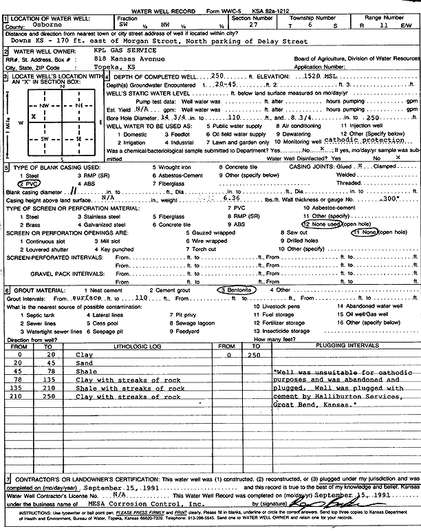
Specific Water Well Detail |
|
|
| Location Info | |||
| Owner: KPL Gas Service | Status: Plugged | ||
| Location: T6S, R11W, Sec. 27, SW NW | County: Osborne | ||
| Directions: 170 ft. east of Morgan St., north parking of Delay Street, Downs | |||
| Latitude: 39.5038413 | Longitude: -98.541735 | Datum NAD 27 | |
| Latitude: 39.5038518 | Longitude: -98.5420781 | Datum NAD 83 | |
| Longitude and latitude calculated by Survey from township-range-section-quarter calls. Only good to within the quarter call accuracy. | |||
| View well on interactive map | |||
| General Info | ||
| Well Depth: 250 ft. | Elevation: 1520 ft. | |
| Static Water Level: ft. | Est. Yield: gpm. | |
| Comp. Date: 15-Sep-1991 | Well Use: Cathodic Protection Borehole | |
| DWR Applic. #: | Other ID: | |
| Driller Info | ||
| Driller: Mesa Corrosion Control, Inc. | License #: | |
| Scanned Form | View scan |
| Casing Info | ||
|
Casing Type:
Diam: in. Casing height above land surface: in | ||
| Grout Info | ||
| Grout used: | From: to ft | |
| Source of Possible Contamination | ||
| Source: | ||
| Direction from well: | Distance: ft | |