|
|
|
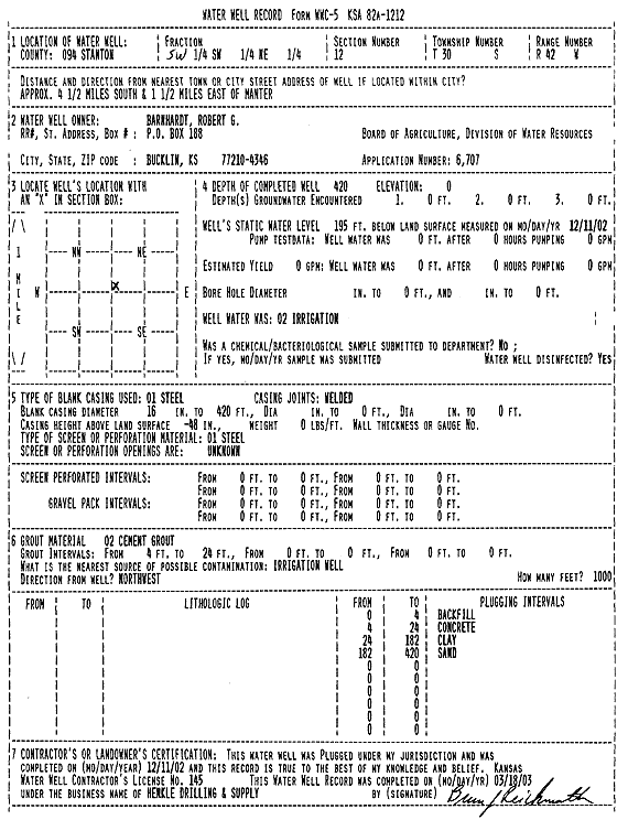
Specific Water Well Detail |
|
|
| Location Info | |||
| Owner: Barnhardt, Robert G. | Status: Plugged | ||
| Location: T30S, R42W, Sec. 12, SW SW NE | County: Stanton | ||
| Directions: From Manter, approx. 4.5 miles South and 1.5 miles East | |||
| Latitude: 37.4552518 | Longitude: -101.8606521 | Datum NAD 27 | |
| Latitude: 37.4552704 | Longitude: -101.8611021 | Datum NAD 83 | |
| Longitude and latitude calculated by Survey from township-range-section-quarter calls. Only good to within the quarter call accuracy. | |||
| View well on interactive map | |||
| General Info | ||
| Well Depth: 420 ft. | Elevation: ft. | |
| Static Water Level: 195 ft. | Est. Yield: gpm. | |
| Comp. Date: 11-Dec-2002 | Well Use: Irrigation | |
| DWR Applic. #: 6707 | Other ID: | |
| Links | |
| View info from Wizard Water Level Data base... | |
| View info from WIMAS Water Right Data base... | |
| Driller Info | ||
| Driller: Richard Henkle Drilling & Supply Co. Inc. | License #: 145 | |
| Scanned Form | View scan |
| Casing Info | ||
|
Casing Type:
Diam: in. Casing height above land surface: in | ||
| Grout Info | ||
| Grout used: | From: to ft | |
| Source of Possible Contamination | ||
| Source: | ||
| Direction from well: | Distance: ft | |