|
|
|
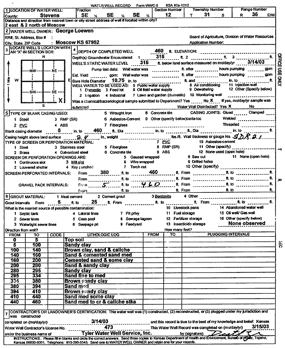
Specific Water Well Detail |
|
|
| Location Info | |||
| Owner: Loewen, George | Status: Constructed | ||
| Location: T31S, R36W, Sec. 12, SE SE SE | County: Stevens | ||
| Directions: from Moscow, 2 mi E and 2 mi N | |||
| Latitude: 37.3595944 | Longitude: -101.1772286 | Datum NAD 27 | |
| Latitude: 37.3596183 | Longitude: -101.1776694 | Datum NAD 83 | |
| Longitude and latitude calculated by Survey from township-range-section-quarter calls. Only good to within the quarter call accuracy. | |||
| View well on interactive map | |||
| General Info | ||
| Well Depth: 460 ft. | Elevation: ft. | |
| Static Water Level: 315 ft. | Est. Yield: gpm. | |
| Comp. Date: 14-Mar-2003 | Well Use: Domestic | |
| DWR Applic. #: | Other ID: | |
| Driller Info | ||
| Driller: Destal Tyler Water Well Service | License #: 473 | |
| Scanned Form | View scan |
|
Chemical Sample Submitted?:
Water Well disinfected?: | ||
| Casing Info | ||
| Casing Type:
Casing Joints: |
Diam: in. to ft | |
| Casing height above land surface: in
Casing Weight: lbs/ft Wall thickness or gauge no.: | ||
| Screen and Perforation Info | ||
| Screen Type: | Screen Openings: | |
| Screen-perforated intervals | From: ft to ft | |
| Gravel pack intervals | From: ft to ft | |
| Grout Info | ||
| Grout used: | From: to ft | |
| Source of Possible Contamination | ||
| Source: | ||
| Direction from well: | Distance: ft | |
| Lithologic Log
(Log data entered by KGS.) | ||
| From: 0 ft. to 5 ft. | top soil | |
| From: 5 ft. to 100 ft. | sandy clay | |
| From: 100 ft. to 140 ft. | brown clay, sand and caliche | |
| From: 140 ft. to 160 ft. | sand and cemented sand med | |
| From: 160 ft. to 200 ft. | cemented sand and some clay | |
| From: 200 ft. to 280 ft. | sand and sandy clay | |
| From: 280 ft. to 295 ft. | sandy clay | |
| From: 295 ft. to 334 ft. | sand fine to med | |
| From: 334 ft. to 380 ft. | brown sandy clay | |
| From: 380 ft. to 394 ft. | sand med | |
| From: 394 ft. to 410 ft. | brown sandy clay | |
| From: 410 ft. to 440 ft. | sand med some clay | |
| From: 440 ft. to 460 ft. | sand, medium to coarse, and caliche streaks | |