|
|
|
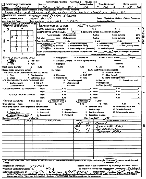
Specific Water Well Detail |
|
|
| Location Info | |||
| Owner: Shelite, Marvin and Connie | Status: Plugged | ||
| Location: T32S, R37W, Sec. 22, NW NW SW | County: Stevens | ||
| Directions: from the NE corner of Hugoton, 4.5 mi N on Hwy 25 | |||
| Latitude: 37.2490553 | Longitude: -101.3374954 | Datum NAD 27 | |
| Latitude: 37.2490792 | Longitude: -101.33793 | Datum NAD 83 | |
| Longitude and latitude calculated by Survey from township-range-section-quarter calls. Only good to within the quarter call accuracy. | |||
| View well on interactive map | |||
| General Info | ||
| Well Depth: 165 ft. | Elevation: ft. | |
| Static Water Level: ft. | Est. Yield: gpm. | |
| Comp. Date: 27-Mar-2003 | Well Use: Domestic | |
| DWR Applic. #: | Other ID: | |
| Driller Info | ||
| Driller: Destal Tyler Water Well Service | License #: 473 | |
| Scanned Form | View scan |
| Casing Info | ||
|
Casing Type:
Diam: in. Casing height above land surface: in | ||
| Grout Info | ||
| Grout used: | From: to ft | |
| Source of Possible Contamination | ||
| Source: | ||
| Direction from well: | Distance: ft | |