|
|
|
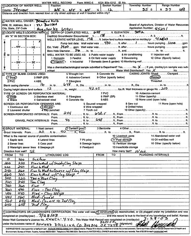
Specific Water Well Detail |
|
|
| Location Info | |||
| Owner: Kolb, Brandon | Status: Constructed | ||
| Location: T35S, R37W, Sec. 12, NE NE NE | County: Stevens | ||
| Directions: | |||
| Latitude: 37.0241294 | Longitude: -101.2848612 | Datum NAD 27 | |
| Latitude: 37.0241555 | Longitude: -101.2853004 | Datum NAD 83 | |
| Longitude and latitude calculated by Survey from township-range-section-quarter calls. Only good to within the quarter call accuracy. | |||
| View well on interactive map | |||
| General Info | ||
| Well Depth: 648 ft. | Elevation: 3092 ft. | |
| Static Water Level: 178 ft. | Est. Yield: 1400 gpm. | |
| Comp. Date: 28-Jul-2003 | Well Use: Irrigation | |
| DWR Applic. #: 45271 | Other ID: | |
| Links | |
| No Wizard information available. | |
| View info from WIMAS Water Right Data base... | |
| Driller Info | ||
| Driller: Howard Drilling Company AG, LLC | License #: 430 | |
| Scanned Form | View scan |
|
Chemical Sample Submitted?:
Water Well disinfected?: | ||
| Casing Info | ||
| Casing Type:
Casing Joints: |
Diam: in. to ft | |
| Casing height above land surface: in
Casing Weight: lbs/ft Wall thickness or gauge no.: | ||
| Screen and Perforation Info | ||
| Screen Type: | Screen Openings: | |
| Screen-perforated intervals | From: ft to ft | |
| Gravel pack intervals | From: ft to ft | |
| Grout Info | ||
| Grout used: | From: to ft | |
| Source of Possible Contamination | ||
| Source: | ||
| Direction from well: | Distance: ft | |
| Lithologic Log
(Log data entered by KGS.) | ||
| From: 0 ft. to 200 ft. | surface | |
| From: 200 ft. to 220 ft. | fine to medium sand with sandy clay strips | |
| From: 220 ft. to 240 ft. | fine to medium sand | |
| From: 240 ft. to 260 ft. | fine to medium to coarse sand with clay strip | |
| From: 260 ft. to 300 ft. | fine to medium sand with clay strip | |
| From: 300 ft. to 320 ft. | tan and blue clay | |
| From: 320 ft. to 340 ft. | tan clay | |
| From: 340 ft. to 360 ft. | fine sand | |
| From: 360 ft. to 400 ft. | fine sand with tan clay | |
| From: 400 ft. to 440 ft. | fine sand with clay strips | |
| From: 440 ft. to 560 ft. | medium-coarse sand | |
| From: 560 ft. to 640 ft. | medium-coarse sand to red clay | |
| From: 640 ft. to 648 ft. | red clay | |