|
|
|
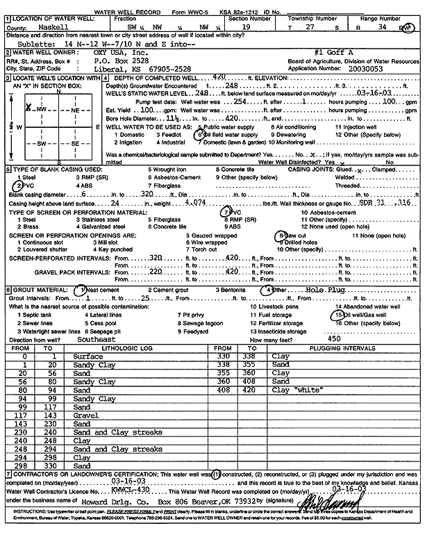
Specific Water Well Detail |
|
|
| Location Info | |||
| Owner: Oxy USA, Inc. | Status: Constructed | ||
| Location: T27S, R34W, Sec. 19, SW NW NW | County: Haskell | ||
| Directions: from Sublette: 14 mi N, 12 mi W, .7 mi N, E into site | |||
| Latitude: 37.6900108 | Longitude: -101.0884806 | Datum NAD 27 | |
| Latitude: 37.6900333 | Longitude: -101.0889281 | Datum NAD 83 | |
| Longitude and latitude calculated by Survey from township-range-section-quarter calls. Only good to within the quarter call accuracy. | |||
| View well on interactive map | |||
| General Info | ||
| Well Depth: 420 ft. | Elevation: ft. | |
| Static Water Level: 248 ft. | Est. Yield: 100 gpm. | |
| Comp. Date: 16-Mar-2003 | Well Use: Oil Field Water Supply | |
| DWR Applic. #: 20030053 | Other ID: Goff A 1 | |
| Links | |
| No Wizard information available. | |
| View info from WIMAS Water Right Data base... | |
| Driller Info | ||
| Driller: Howard Drilling Company AG, LLC | License #: 430 | |
| Scanned Form | View scan |
|
Chemical Sample Submitted?:
Water Well disinfected?: | ||
| Casing Info | ||
| Casing Type:
Casing Joints: |
Diam: in. to ft | |
| Casing height above land surface: in
Casing Weight: lbs/ft Wall thickness or gauge no.: | ||
| Screen and Perforation Info | ||
| Screen Type: | Screen Openings: | |
| Screen-perforated intervals | From: ft to ft | |
| Gravel pack intervals | From: ft to ft | |
| Grout Info | ||
| Grout used: | From: to ft | |
| Source of Possible Contamination | ||
| Source: | ||
| Direction from well: | Distance: ft | |
| Lithologic Log
(Log data entered by KGS.) | ||
| From: 0 ft. to 1 ft. | surface | |
| From: 1 ft. to 20 ft. | sandy clay | |
| From: 20 ft. to 56 ft. | sand | |
| From: 56 ft. to 80 ft. | sandy clay | |
| From: 80 ft. to 94 ft. | sand | |
| From: 94 ft. to 99 ft. | sandy clay | |
| From: 99 ft. to 117 ft. | sand | |
| From: 117 ft. to 143 ft. | gravel | |
| From: 143 ft. to 230 ft. | sand | |
| From: 230 ft. to 240 ft. | sand and clay streaks | |
| From: 240 ft. to 248 ft. | clay | |
| From: 248 ft. to 294 ft. | sand and clay streaks | |
| From: 294 ft. to 298 ft. | clay | |
| From: 298 ft. to 330 ft. | sand | |
| From: 330 ft. to 338 ft. | clay | |
| From: 338 ft. to 355 ft. | sand | |
| From: 355 ft. to 360 ft. | clay | |
| From: 360 ft. to 408 ft. | sand | |
| From: 408 ft. to 420 ft. | clay, white | |