|
|
|
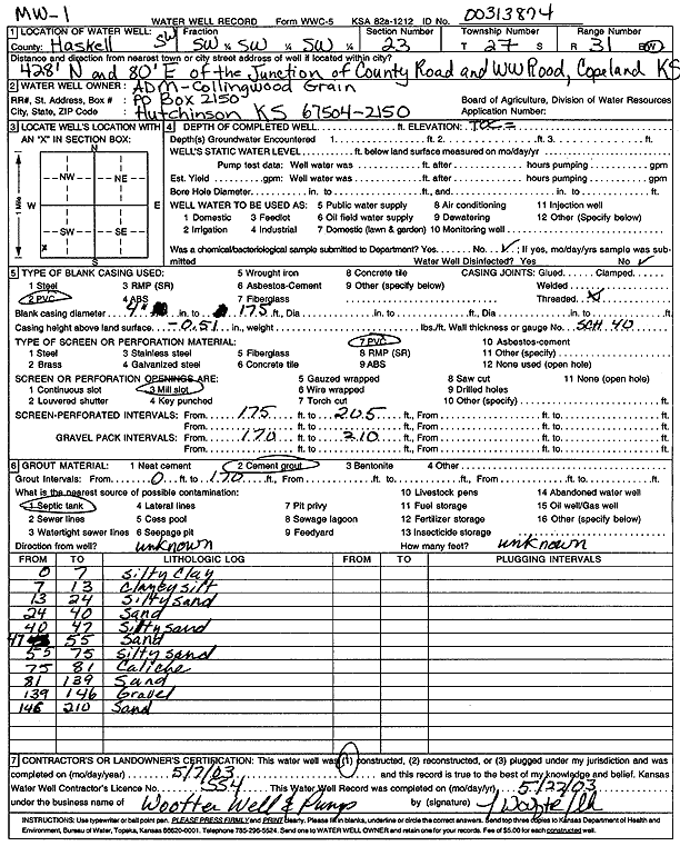
Specific Water Well Detail |
|
|
| Location Info | |||
| Owner: ADM-Collingwood Grain | Status: Constructed | ||
| Location: T27S, R31W, Sec. 23, SW SW SW | County: Haskell | ||
| Directions: 428 feet North and 80 feet East of the Junction of County Rd and WW Road in Copeland | |||
| Latitude: 37.679224 | Longitude: -100.6873587 | Datum NAD 27 | |
| Latitude: 37.679248 | Longitude: -100.6877939 | Datum NAD 83 | |
| Longitude and latitude calculated by Survey from township-range-section-quarter calls. Only good to within the quarter call accuracy. | |||
| View well on interactive map | |||
| General Info | ||
| Well Depth: 210 ft. | Elevation: ft. | |
| Static Water Level: ft. | Est. Yield: gpm. | |
| Comp. Date: 07-May-2003 | Well Use: Monitoring well/observation/piezometer | |
| DWR Applic. #: | Other ID: MW 1 | |
| Driller Info | ||
| Driller: Jay C. Woofter Pump & Well, Inc. | License #: 554 | |
| Scanned Form | View scan |
|
Chemical Sample Submitted?:
Water Well disinfected?: | ||
| Casing Info | ||
| Casing Type:
Casing Joints: |
Diam: in. to ft | |
| Casing height above land surface: in
Casing Weight: lbs/ft Wall thickness or gauge no.: | ||
| Screen and Perforation Info | ||
| Screen Type: | Screen Openings: | |
| Screen-perforated intervals | From: ft to ft | |
| Gravel pack intervals | From: ft to ft | |
| Grout Info | ||
| Grout used: | From: to ft | |
| Source of Possible Contamination | ||
| Source: | ||
| Direction from well: | Distance: ft | |
| Lithologic Log
(Log data entered by KGS.) | ||
| From: 0 ft. to 7 ft. | silty clay | |
| From: 7 ft. to 13 ft. | clayey silt | |
| From: 13 ft. to 24 ft. | silty sand | |
| From: 24 ft. to 40 ft. | sand | |
| From: 40 ft. to 47 ft. | silty sand | |
| From: 47 ft. to 55 ft. | sand | |
| From: 55 ft. to 75 ft. | silty sand | |
| From: 75 ft. to 81 ft. | caliche | |
| From: 81 ft. to 139 ft. | sand | |
| From: 139 ft. to 146 ft. | gravel | |
| From: 146 ft. to 210 ft. | sand | |