|
|
|
Specific Water Well Detail |
|
|
| Location Info | |||
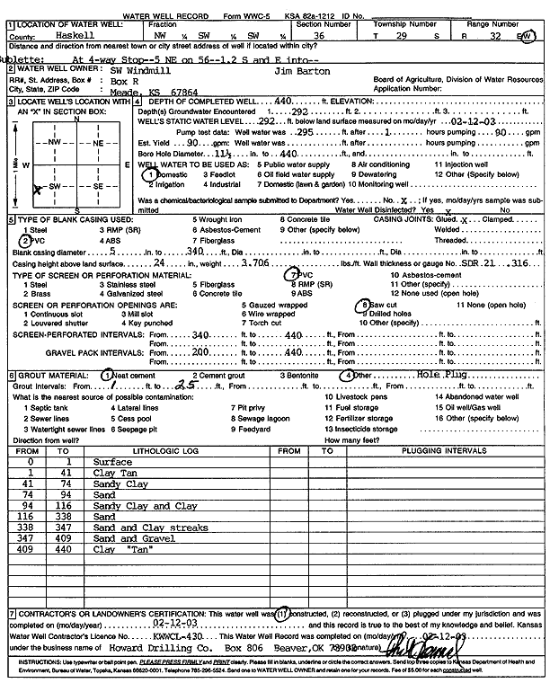
| Owner: Southwest Windmill | Status: Constructed | ||
| Location: T29S, R32W, Sec. 36, NW SW SW | County: Haskell | ||
| Directions: From Sublette at 4-way stop: 5 miles NE on Hwy 56, 1.2 mi S, E into Jim Barton | |||
| Latitude: 37.4775809 | Longitude: -100.7784194 | Datum NAD 27 | |
| Latitude: 37.4776051 | Longitude: -100.7788574 | Datum NAD 83 | |
| Longitude and latitude calculated by Survey from township-range-section-quarter calls. Only good to within the quarter call accuracy. | |||
| View well on interactive map | |||
| General Info | ||
| Well Depth: 440 ft. | Elevation: ft. | |
| Static Water Level: 292 ft. | Est. Yield: 90 gpm. | |
| Comp. Date: 12-Feb-2003 | Well Use: Domestic | |
| DWR Applic. #: | Other ID: | |
| Driller Info | ||
| Driller: Howard Drilling Company AG, LLC | License #: 430 | |
| Scanned Form | View scan |
|
Chemical Sample Submitted?:
Water Well disinfected?: | ||
| Casing Info | ||
| Casing Type:
Casing Joints: |
Diam: in. to ft | |
| Casing height above land surface: in
Casing Weight: lbs/ft Wall thickness or gauge no.: | ||
| Screen and Perforation Info | ||
| Screen Type: | Screen Openings: | |
| Screen-perforated intervals | From: ft to ft | |
| Gravel pack intervals | From: ft to ft | |
| Grout Info | ||
| Grout used: | From: to ft | |
| Source of Possible Contamination | ||
| Source: | ||
| Direction from well: | Distance: ft | |
| Lithologic Log
(Log data entered by KGS.) | ||
| From: 0 ft. to 1 ft. | surface | |
| From: 1 ft. to 41 ft. | clay tan | |
| From: 41 ft. to 74 ft. | sandy clay | |
| From: 74 ft. to 94 ft. | sand | |
| From: 94 ft. to 116 ft. | sandy clay and clay | |
| From: 116 ft. to 338 ft. | sand | |
| From: 338 ft. to 347 ft. | sand and clay streaks | |
| From: 347 ft. to 409 ft. | sand and gravel | |
| From: 409 ft. to 440 ft. | clay, tan | |