|
|
|
Specific Water Well Detail |
|
|
| Location Info | |||
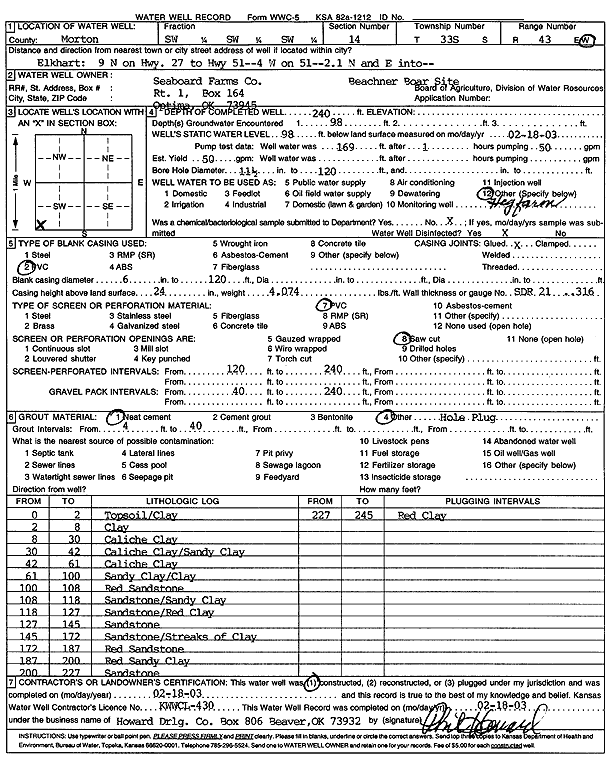
| Owner: Seaboard Farms Co. | Status: Constructed | ||
| Location: T33S, R43W, Sec. 14, SW SW SW | County: Morton | ||
| Directions: from Elkhart, 9 mi N on Hwy 27 to Hwy 51, 4 mi W on 51, 2.1 mi N and E into Beachner Boar Site | |||
| Latitude: 37.1715447 | Longitude: -101.9704615 | Datum NAD 27 | |
| Latitude: 37.1715667 | Longitude: -101.9709098 | Datum NAD 83 | |
| Longitude and latitude calculated by Survey from township-range-section-quarter calls. Only good to within the quarter call accuracy. | |||
| View well on interactive map | |||
| General Info | ||
| Well Depth: 240 ft. | Elevation: ft. | |
| Static Water Level: 98 ft. | Est. Yield: 50 gpm. | |
| Comp. Date: 18-Feb-2003 | Well Use: Domestic, Livestock | |
| DWR Applic. #: | Other ID: | |
| Links | |
| No Wizard information available. | |
| View info from WIMAS Water Right Data base... | |
| Driller Info | ||
| Driller: Howard Drilling Company AG, LLC | License #: 430 | |
| Scanned Form | View scan |
|
Chemical Sample Submitted?:
Water Well disinfected?: | ||
| Casing Info | ||
| Casing Type:
Casing Joints: |
Diam: in. to ft | |
| Casing height above land surface: in
Casing Weight: lbs/ft Wall thickness or gauge no.: | ||
| Screen and Perforation Info | ||
| Screen Type: | Screen Openings: | |
| Screen-perforated intervals | From: ft to ft | |
| Gravel pack intervals | From: ft to ft | |
| Grout Info | ||
| Grout used: | From: to ft | |
| Source of Possible Contamination | ||
| Source: | ||
| Direction from well: | Distance: ft | |
| Lithologic Log
(Log data entered by KGS.) | ||
| From: 0 ft. to 2 ft. | topsoil/clay | |
| From: 2 ft. to 8 ft. | clay | |
| From: 8 ft. to 30 ft. | caliche clay | |
| From: 30 ft. to 42 ft. | caliche clay/sandy clay | |
| From: 42 ft. to 61 ft. | caliche clay | |
| From: 61 ft. to 100 ft. | sandy clay/clay | |
| From: 100 ft. to 108 ft. | red sandstone | |
| From: 108 ft. to 118 ft. | sandstone/sandy clay | |
| From: 118 ft. to 127 ft. | sandstone/red clay | |
| From: 127 ft. to 145 ft. | sandstone | |
| From: 145 ft. to 172 ft. | sandstone/streaks of clay | |
| From: 172 ft. to 187 ft. | red sandstone | |
| From: 187 ft. to 200 ft. | red sandy clay | |
| From: 200 ft. to 227 ft. | sandstone | |
| From: 227 ft. to 245 ft. | red clay | |