|
|
|
Specific Water Well Detail |
|
|
| Location Info | |||
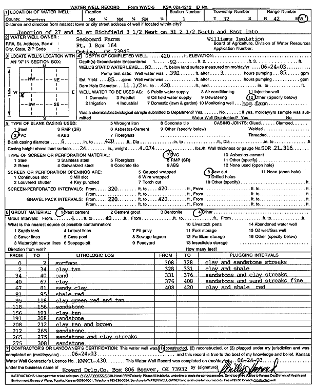
| Owner: Seaboard Farms | Status: Constructed | ||
| Location: T32S, R42W, Sec. 1, NW NW SW | County: Morton | ||
| Directions: from Hwy 27 and 51 at Richfield, 3.5 mi W on 51, 2.5 mi N and E into Williams Isolation | |||
| Latitude: 37.2934641 | Longitude: -101.8445522 | Datum NAD 27 | |
| Latitude: 37.2934862 | Longitude: -101.8449986 | Datum NAD 83 | |
| Longitude and latitude calculated by Survey from township-range-section-quarter calls. Only good to within the quarter call accuracy. | |||
| View well on interactive map | |||
| General Info | ||
| Well Depth: 420 ft. | Elevation: ft. | |
| Static Water Level: 92 ft. | Est. Yield: 85 gpm. | |
| Comp. Date: 24-Jun-2003 | Well Use: Feedlot | |
| DWR Applic. #: | Other ID: | |
| Links | |
| No Wizard information available. | |
| View info from WIMAS Water Right Data base... | |
| Driller Info | ||
| Driller: Howard Drilling Company AG, LLC | License #: 430 | |
| Scanned Form | View scan |
|
Chemical Sample Submitted?:
Water Well disinfected?: | ||
| Casing Info | ||
| Casing Type:
Casing Joints: |
Diam: in. to ft | |
| Casing height above land surface: in
Casing Weight: lbs/ft Wall thickness or gauge no.: | ||
| Screen and Perforation Info | ||
| Screen Type: | Screen Openings: | |
| Screen-perforated intervals | From: ft to ft | |
| Gravel pack intervals | From: ft to ft | |
| Grout Info | ||
| Grout used: | From: to ft | |
| Source of Possible Contamination | ||
| Source: | ||
| Direction from well: | Distance: ft | |
| Lithologic Log
(Log data entered by KGS.) | ||
| From: 0 ft. to 2 ft. | surface | |
| From: 2 ft. to 34 ft. | clay tan | |
| From: 34 ft. to 40 ft. | sand | |
| From: 40 ft. to 81 ft. | sandy clay | |
| From: 81 ft. to 95 ft. | shale red | |
| From: 95 ft. to 118 ft. | clay green red and tan | |
| From: 118 ft. to 156 ft. | sandstone | |
| From: 156 ft. to 191 ft. | clay tan | |
| From: 191 ft. to 208 ft. | sandstone | |
| From: 208 ft. to 212 ft. | clay, tan and brown | |
| From: 212 ft. to 265 ft. | sandstone | |
| From: 265 ft. to 275 ft. | sandstone and clay streaks | |
| From: 275 ft. to 308 ft. | sandstone | |
| From: 308 ft. to 328 ft. | clay and sandstone streaks | |
| From: 328 ft. to 331 ft. | clay and shale | |
| From: 331 ft. to 376 ft. | sandstone and clay streaks | |
| From: 376 ft. to 408 ft. | sandstone and sand streaks fine | |
| From: 408 ft. to 420 ft. | clay and shale red | |