|
|
|
Specific Water Well Detail |
|
|
| Location Info | |||
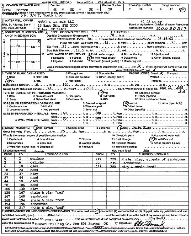
| Owner: Nadel and Gussman LLC | Status: Constructed | ||
| Location: T34S, R42W, Sec. 28, NE NE NE | County: Morton | ||
| Directions: From Elkhart, 5 miles North, .75 mile East, South into site | |||
| Latitude: 37.0677328 | Longitude: -101.8822823 | Datum NAD 27 | |
| Latitude: 37.0677562 | Longitude: -101.882727 | Datum NAD 83 | |
| Longitude and latitude calculated by Survey from township-range-section-quarter calls. Only good to within the quarter call accuracy. | |||
| View well on interactive map | |||
| General Info | ||
| Well Depth: 280 ft. | Elevation: ft. | |
| Static Water Level: 78 ft. | Est. Yield: 75 gpm. | |
| Comp. Date: 16-Aug-2003 | Well Use: Oil Field Water Supply | |
| DWR Applic. #: 200030217 | Other ID: Riley 2-28 | |
| Links | |
| No Wizard information available. | |
| View info from WIMAS Water Right Data base... | |
| Driller Info | ||
| Driller: Howard Drilling Company AG, LLC | License #: 430 | |
| Scanned Form | View scan |
|
Chemical Sample Submitted?:
Water Well disinfected?: | ||
| Casing Info | ||
| Casing Type:
Casing Joints: |
Diam: in. to ft | |
| Casing height above land surface: in
Casing Weight: lbs/ft Wall thickness or gauge no.: | ||
| Screen and Perforation Info | ||
| Screen Type: | Screen Openings: | |
| Screen-perforated intervals | From: ft to ft | |
| Gravel pack intervals | From: ft to ft | |
| Grout Info | ||
| Grout used: | From: to ft | |
| Source of Possible Contamination | ||
| Source: | ||
| Direction from well: | Distance: ft | |
| Lithologic Log
(Log data entered by KGS.) | ||
| From: 0 ft. to 2 ft. | surface | |
| From: 2 ft. to 6 ft. | caliche | |
| From: 6 ft. to 18 ft. | clay | |
| From: 18 ft. to 24 ft. | sand | |
| From: 24 ft. to 37 ft. | clay | |
| From: 37 ft. to 44 ft. | sand | |
| From: 44 ft. to 58 ft. | clay | |
| From: 58 ft. to 106 ft. | sand | |
| From: 106 ft. to 130 ft. | clay | |
| From: 130 ft. to 167 ft. | shale and clay, red | |
| From: 167 ft. to 168 ft. | sandstone | |
| From: 168 ft. to 194 ft. | shale and clay, red | |
| From: 194 ft. to 196 ft. | sandstone | |
| From: 196 ft. to 217 ft. | shale and clay, red | |
| From: 217 ft. to 228 ft. | shale, clay, streaks of sandstone | |
| From: 228 ft. to 235 ft. | sandstone | |
| From: 235 ft. to 280 ft. | clay and shale, red | |