|
|
|
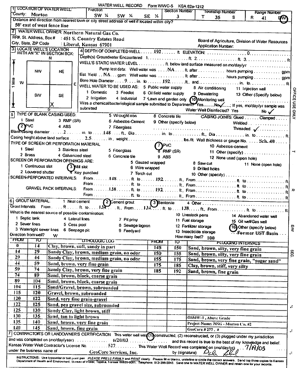
Specific Water Well Detail |
|
|
| Location Info | |||
| Owner: Northern Natural Gas Co. | Status: Constructed | ||
| Location: T35S, R41W, Sec. 3, SW SW SE | County: Morton | ||
| Directions: 50 feet east of west fence line | |||
| Latitude: 37.0261883 | Longitude: -101.7620375 | Datum NAD 27 | |
| Latitude: 37.0262131 | Longitude: -101.7624777 | Datum NAD 83 | |
| Longitude and latitude calculated by Survey from township-range-section-quarter calls. Only good to within the quarter call accuracy. | |||
| View well on interactive map | |||
| General Info | ||
| Well Depth: 192 ft. | Elevation: ft. | |
| Static Water Level: ft. | Est. Yield: gpm. | |
| Comp. Date: 20-Jun-2003 | Well Use: Monitoring well/observation/piezometer | |
| DWR Applic. #: | Other ID: OSMW 1 | |
| Driller Info | ||
| Driller: GeoCore Services Inc. | License #: 527 | |
| Scanned Form | View scan |
|
Chemical Sample Submitted?:
Water Well disinfected?: | ||
| Casing Info | ||
| Casing Type:
Casing Joints: |
Diam: in. to ft | |
| Casing height above land surface: in
Casing Weight: lbs/ft Wall thickness or gauge no.: | ||
| Screen and Perforation Info | ||
| Screen Type: | Screen Openings: | |
| Screen-perforated intervals | From: ft to ft | |
| Gravel pack intervals | From: ft to ft | |
| Grout Info | ||
| Grout used: | From: to ft | |
| Source of Possible Contamination | ||
| Source: | ||
| Direction from well: | Distance: ft | |
| Lithologic Log
(Log data entered by KGS.) | ||
| From: 0 ft. to 14 ft. | clay, brown, soft, sandy in part | |
| From: 14 ft. to 29 ft. | sandy clay, brown, medium grain, no odor | |
| From: 29 ft. to 44 ft. | sandy clay, brown, medium grain, no odor | |
| From: 44 ft. to 59 ft. | sand, brown, very fine grain | |
| From: 59 ft. to 74 ft. | sandy clay, brown, very fine grain | |
| From: 74 ft. to 89 ft. | sand, brown, black, coarse grain | |
| From: 89 ft. to 104 ft. | sand, brown, black, coarse grain | |
| From: 104 ft. to 115 ft. | sand/gravel, brown, subrounded | |
| From: 115 ft. to 120 ft. | gravel, brown, subrounded | |
| From: 120 ft. to 122 ft. | sand, very fine grain-gravel | |
| From: 122 ft. to 125 ft. | sand, pea gravel size, subrounded | |
| From: 125 ft. to 130 ft. | sandy clay, light brown, stiff | |
| From: 130 ft. to 135 ft. | sand, tan to light brown | |
| From: 135 ft. to 140 ft. | sand, brown, very fine grain | |
| From: 140 ft. to 145 ft. | sand, brown, fine grain | |
| From: 145 ft. to 150 ft. | sand, brown, silty, very fine grain | |
| From: 150 ft. to 155 ft. | sand, brown, silty, very fine grain | |
| From: 155 ft. to 175 ft. | sand, brown, very fine grain (sugar sand) | |
| From: 175 ft. to 185 ft. | clay, brown, stiff, very silty | |
| From: 185 ft. to 192 ft. | sand, brown, fine grain | |