|
|
|
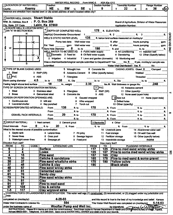
Specific Water Well Detail |
|
|
| Location Info | |||
| Owner: Stable, Stuart | Status: Constructed | ||
| Location: T22S, R36W, Sec. 9, NE SW SE | County: Kearny | ||
| Directions: | |||
| Latitude: 38.150739 | Longitude: -101.2726816 | Datum NAD 27 | |
| Latitude: 38.1507595 | Longitude: -101.2731248 | Datum NAD 83 | |
| Longitude and latitude calculated by Survey from township-range-section-quarter calls. Only good to within the quarter call accuracy. | |||
| View well on interactive map | |||
| General Info | ||
| Well Depth: 178 ft. | Elevation: ft. | |
| Static Water Level: 135 ft. | Est. Yield: gpm. | |
| Comp. Date: 28-Apr-2003 | Well Use: Domestic | |
| DWR Applic. #: | Other ID: | |
| Driller Info | ||
| Driller: Jay C. Woofter Pump & Well, Inc. | License #: 554 | |
| Scanned Form | View scan |
|
Chemical Sample Submitted?:
Water Well disinfected?: | ||
| Casing Info | ||
| Casing Type:
Casing Joints: |
Diam: in. to ft | |
| Casing height above land surface: in
Casing Weight: lbs/ft Wall thickness or gauge no.: | ||
| Screen and Perforation Info | ||
| Screen Type: | Screen Openings: | |
| Screen-perforated intervals | From: ft to ft | |
| Gravel pack intervals | From: ft to ft | |
| Grout Info | ||
| Grout used: | From: to ft | |
| Source of Possible Contamination | ||
| Source: | ||
| Direction from well: | Distance: ft | |
| Lithologic Log
(Log data entered by KGS.) | ||
| From: 0 ft. to 2 ft. | surface | |
| From: 2 ft. to 4 ft. | loess | |
| From: 4 ft. to 15 ft. | fine sand | |
| From: 15 ft. to 30 ft. | caliche and sandstone | |
| From: 30 ft. to 37 ft. | fine sand with caliche streaks | |
| From: 37 ft. to 48 ft. | caliche and clay | |
| From: 48 ft. to 57 ft. | fine sand with clay streaks | |
| From: 57 ft. to 61 ft. | cemented sand | |
| From: 61 ft. to 70 ft. | sandy clay | |
| From: 70 ft. to 74 ft. | fine sand with clay streaks | |
| From: 74 ft. to 81 ft. | clay | |
| From: 81 ft. to 97 ft. | fine to medium sand | |
| From: 97 ft. to 105 ft. | clay and caliche | |
| From: 105 ft. to 117 ft. | clay with gravel streaks | |
| From: 117 ft. to 125 ft. | fine to medium sand with clay streaks | |
| From: 125 ft. to 157 ft. | fine to some medium sand with clay streaks | |
| From: 157 ft. to 165 ft. | clay | |
| From: 165 ft. to 178 ft. | fine to medium sand and some gravel | |
| From: 178 ft. to 190 ft. | yellow ochre | |
| From: 190 ft. to ft. | black shale | |