|
|
|
Specific Water Well Detail |
|
|
| Location Info | |||
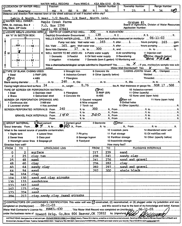
| Owner: Maple Creek Farms | Status: Constructed | ||
| Location: T23S, R36W, Sec. 30, SW SE NW | County: Kearny | ||
| Directions: from Lakin: 6 mi N, 3 mi W, .5 mi S, .25 mi E, N into site | |||
| Latitude: 38.0251046 | Longitude: -101.3160686 | Datum NAD 27 | |
| Latitude: 38.0251236 | Longitude: -101.316515 | Datum NAD 83 | |
| Longitude and latitude calculated by Survey from township-range-section-quarter calls. Only good to within the quarter call accuracy. | |||
| View well on interactive map | |||
| General Info | ||
| Well Depth: 300 ft. | Elevation: ft. | |
| Static Water Level: 139 ft. | Est. Yield: 165 gpm. | |
| Comp. Date: 11-Jun-2003 | Well Use: Domestic, Livestock | |
| DWR Applic. #: | Other ID: Graham 1 | |
| Links | |
| No Wizard information available. | |
| View info from WIMAS Water Right Data base... | |
| Driller Info | ||
| Driller: Howard Drilling Company AG, LLC | License #: 430 | |
| Scanned Form | View scan |
|
Chemical Sample Submitted?:
Water Well disinfected?: | ||
| Casing Info | ||
| Casing Type:
Casing Joints: |
Diam: in. to ft | |
| Casing height above land surface: in
Casing Weight: lbs/ft Wall thickness or gauge no.: | ||
| Screen and Perforation Info | ||
| Screen Type: | Screen Openings: | |
| Screen-perforated intervals | From: ft to ft | |
| Gravel pack intervals | From: ft to ft | |
| Grout Info | ||
| Grout used: | From: to ft | |
| Source of Possible Contamination | ||
| Source: | ||
| Direction from well: | Distance: ft | |
| Lithologic Log
(Log data entered by KGS.) | ||
| From: 0 ft. to 2 ft. | surface | |
| From: 2 ft. to 25 ft. | clay tan | |
| From: 25 ft. to 48 ft. | sand | |
| From: 48 ft. to 60 ft. | clay | |
| From: 60 ft. to 64 ft. | sandy clay | |
| From: 64 ft. to 94 ft. | sand | |
| From: 94 ft. to 104 ft. | clay | |
| From: 104 ft. to 130 ft. | sand and clay streaks | |
| From: 130 ft. to 133 ft. | sandstone | |
| From: 133 ft. to 167 ft. | sand | |
| From: 167 ft. to 173 ft. | clay | |
| From: 173 ft. to 204 ft. | sand | |
| From: 204 ft. to 217 ft. | clay sandy clay/sand streaks | |
| From: 217 ft. to 239 ft. | sand | |
| From: 239 ft. to 241 ft. | sandy clay | |
| From: 241 ft. to 276 ft. | sand and gravel | |
| From: 276 ft. to 282 ft. | clay | |
| From: 282 ft. to 297 ft. | sand and gravel | |
| From: 297 ft. to 300 ft. | shale black | |