|
|
|
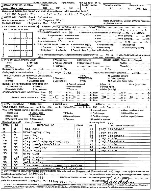
Specific Water Well Detail |
|
|
| Location Info | |||
| Owner: Debacker, Jack | Status: Constructed | ||
| Location: T11S, R16E, Sec. 8, NW NE SW | County: Shawnee | ||
| Directions: 3221 NW Topeka Blvd - from Topeka: .125 mi N | |||
| Latitude: 39.1086533 | Longitude: -95.6631691 | Datum NAD 27 | |
| Latitude: 39.1086526 | Longitude: -95.6634279 | Datum NAD 83 | |
| Longitude and latitude calculated by Survey from township-range-section-quarter calls. Only good to within the quarter call accuracy. | |||
| View well on interactive map | |||
| General Info | ||
| Well Depth: 84 ft. | Elevation: ft. | |
| Static Water Level: 56 ft. | Est. Yield: 3 gpm. | |
| Comp. Date: 26-Feb-2003 | Well Use: Domestic | |
| DWR Applic. #: | Other ID: | |
| Driller Info | ||
| Driller: Strader Drilling Co., Inc. | License #: 182 | |
| Scanned Form | View scan |
|
Chemical Sample Submitted?:
Water Well disinfected?: | ||
| Casing Info | ||
| Casing Type:
Casing Joints: |
Diam: in. to ft | |
| Casing height above land surface: in
Casing Weight: lbs/ft Wall thickness or gauge no.: | ||
| Screen and Perforation Info | ||
| Screen Type: | Screen Openings: | |
| Screen-perforated intervals | From: ft to ft | |
| Gravel pack intervals | From: ft to ft | |
| Grout Info | ||
| Grout used: | From: to ft | |
| Source of Possible Contamination | ||
| Source: | ||
| Direction from well: | Distance: ft | |
| Lithologic Log
(Log data entered by KGS.) | ||
| From: 0 ft. to 2 ft. | top soil | |
| From: 2 ft. to 5 ft. | brown-gray clay | |
| From: 5 ft. to 7 ft. | tan clay | |
| From: 7 ft. to 17 ft. | yellow clay | |
| From: 17 ft. to 22 ft. | clay, yellow, gray, boulders | |
| From: 22 ft. to 31 ft. | clay, tan, yellow, silty | |
| From: 31 ft. to 33 ft. | clay, tan, gray | |
| From: 33 ft. to 35 ft. | black clay | |
| From: 35 ft. to 38 ft. | gray clay | |
| From: 38 ft. to 41 ft. | yellow clay | |
| From: 41 ft. to 50 ft. | gray clay | |
| From: 50 ft. to 53 ft. | yellow clay | |
| From: 53 ft. to 57 ft. | fine sand, coarse sand, yellow-brown | |
| From: 57 ft. to 62 ft. | fine sand, coarse sand, pea gravel 3/8, yellow-brown | |
| From: 62 ft. to 63 ft. | gray limestone | |
| From: 63 ft. to 65 ft. | gray shale | |
| From: 65 ft. to 66 ft. | gray limestone | |
| From: 66 ft. to 68 ft. | gray shale | |
| From: 68 ft. to 69 ft. | gray limestone | |
| From: 69 ft. to 71 ft. | gray shale | |
| From: 71 ft. to 78 ft. | gray limestone | |
| From: 78 ft. to 84 ft. | gray shale | |