|
|
|
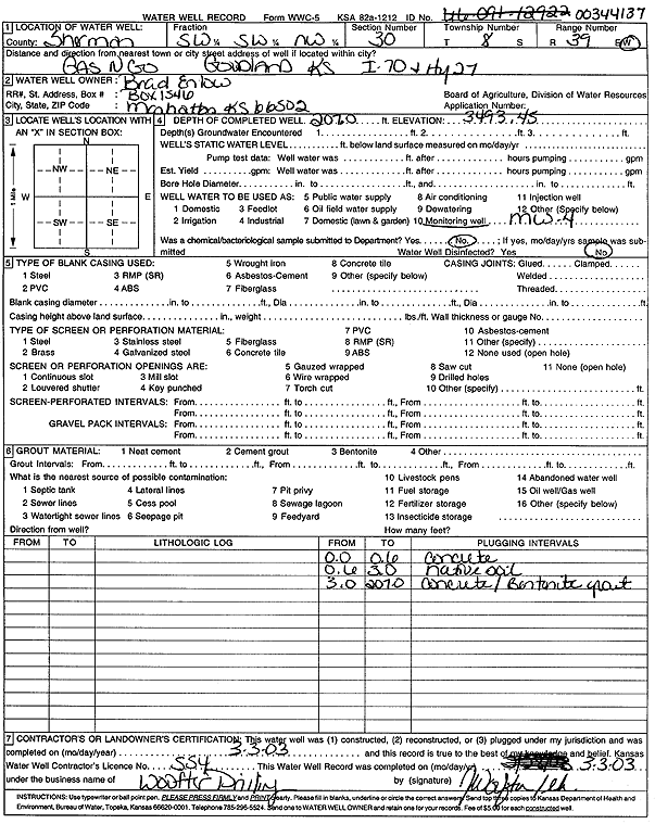
Specific Water Well Detail |
|
|
| Location Info | |||
| Owner: Enlow, Brad | Status: Plugged | ||
| Location: T8S, R39W, Sec. 30, SW SW NW | County: Sherman | ||
| Directions: I-70 and Hwy 27, Gas N Go, Goodland | |||
| Latitude: 39.3303165 | Longitude: -101.7243875 | Datum NAD 27 | |
| Latitude: 39.3303165 | Longitude: -101.724838 | Datum NAD 83 | |
| Longitude and latitude calculated by Survey from township-range-section-quarter calls. Only good to within the quarter call accuracy. | |||
| View well on interactive map | |||
| General Info | ||
| Well Depth: 207 ft. | Elevation: 3493.45 ft. | |
| Static Water Level: ft. | Est. Yield: gpm. | |
| Comp. Date: 03-Mar-2003 | Well Use: Monitoring well/observation/piezometer | |
| DWR Applic. #: | Other ID: MW 4 | |
| Driller Info | ||
| Driller: Jay C. Woofter Pump & Well, Inc. | License #: 554 | |
| Scanned Form | View scan |
| Casing Info | ||
|
Casing Type:
Diam: in. Casing height above land surface: in | ||
| Grout Info | ||
| Grout used: | From: to ft | |
| Source of Possible Contamination | ||
| Source: | ||
| Direction from well: | Distance: ft | |