|
|
|
Specific Water Well Detail |
|
|
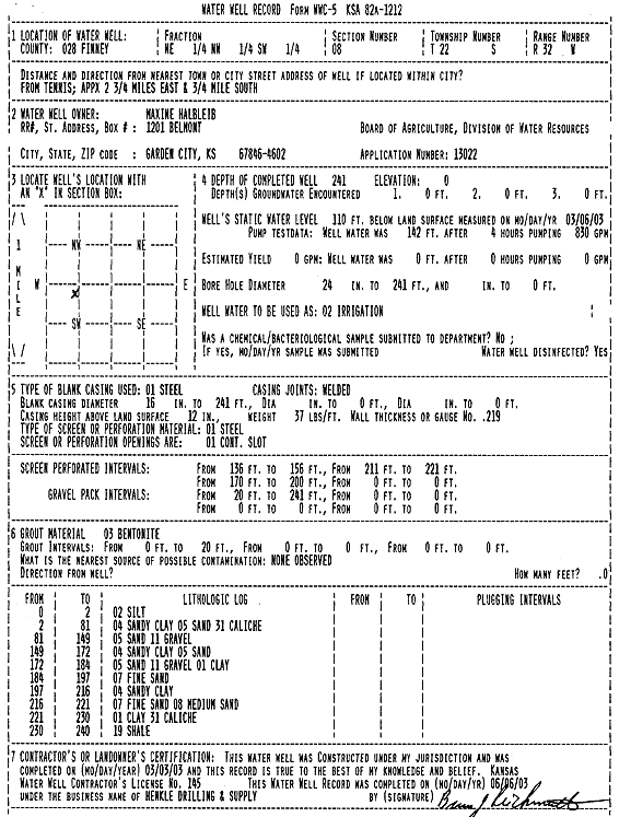
| Location Info | |||
| Owner: Halbleib, Maxine | Status: Constructed | ||
| Location: T22S, R32W, Sec. 8, NE NW SW | County: Finney | ||
| Directions: from Tennis, 2.75 mi E and 0.75 mi S | |||
| Latitude: 38.1553281 | Longitude: -100.8618456 | Datum NAD 27 | |
| Latitude: 38.1553503 | Longitude: -100.8622811 | Datum NAD 83 | |
| Longitude and latitude calculated by Survey from township-range-section-quarter calls. Only good to within the quarter call accuracy. | |||
| View well on interactive map | |||
| General Info | ||
| Well Depth: 241 ft. | Elevation: ft. | |
| Static Water Level: 110 ft. | Est. Yield: gpm. | |
| Comp. Date: 03-Mar-2003 | Well Use: Irrigation | |
| DWR Applic. #: 13022 | Other ID: | |
| Driller Info | ||
| Driller: Richard Henkle Drilling & Supply Co. Inc. | License #: 145 | |
| Scanned Form | View scan |
|
Chemical Sample Submitted?:
Water Well disinfected?: | ||
| Casing Info | ||
| Casing Type:
Casing Joints: |
Diam: in. to ft | |
| Casing height above land surface: in
Casing Weight: lbs/ft Wall thickness or gauge no.: | ||
| Screen and Perforation Info | ||
| Screen Type: | Screen Openings: | |
| Screen-perforated intervals | From: ft to ft | |
| Gravel pack intervals | From: ft to ft | |
| Grout Info | ||
| Grout used: | From: to ft | |
| Source of Possible Contamination | ||
| Source: | ||
| Direction from well: | Distance: ft | |
| Lithologic Log
(Log data entered by KGS.) | ||
| From: 0 ft. to 2 ft. | silt | |
| From: 2 ft. to 81 ft. | sandy clay sand caliche | |
| From: 81 ft. to 149 ft. | sand gravel | |
| From: 149 ft. to 172 ft. | sandy clay sand | |
| From: 172 ft. to 184 ft. | sand gravel clay | |
| From: 184 ft. to 197 ft. | fine sand | |
| From: 197 ft. to 216 ft. | sandy clay | |
| From: 216 ft. to 221 ft. | fine sand medium sand | |
| From: 221 ft. to 230 ft. | clay caliche | |
| From: 230 ft. to 240 ft. | shale | |