|
|
|
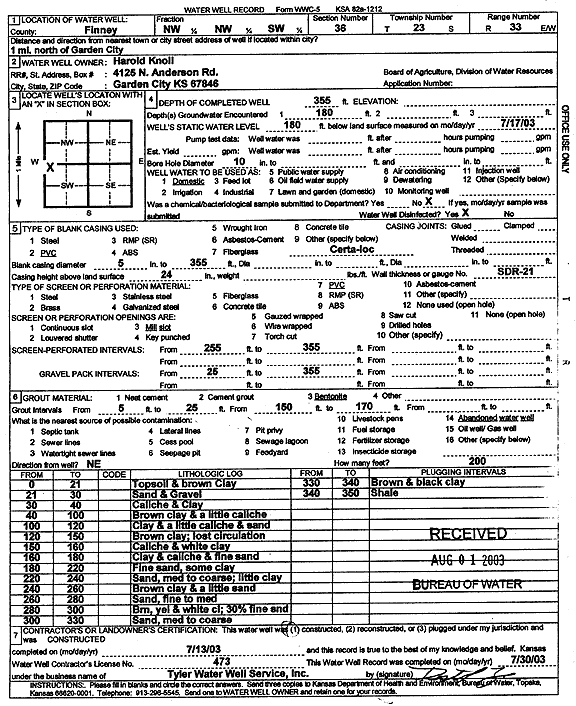
Specific Water Well Detail |
|
|
| Location Info | |||
| Owner: Knoll, Harold | Status: Constructed | ||
| Location: T23S, R33W, Sec. 36, NW NW SW | County: Finney | ||
| Directions: from Garden City. 1 mi N | |||
| Latitude: 38.0103385 | Longitude: -100.9002173 | Datum NAD 27 | |
| Latitude: 38.0103618 | Longitude: -100.9006575 | Datum NAD 83 | |
| Longitude and latitude calculated by Survey from township-range-section-quarter calls. Only good to within the quarter call accuracy. | |||
| View well on interactive map | |||
| General Info | ||
| Well Depth: 355 ft. | Elevation: ft. | |
| Static Water Level: 180 ft. | Est. Yield: gpm. | |
| Comp. Date: 13-Jul-2003 | Well Use: Domestic | |
| DWR Applic. #: | Other ID: | |
| Driller Info | ||
| Driller: Destal Tyler Water Well Service | License #: 473 | |
| Scanned Form | View scan |
|
Chemical Sample Submitted?:
Water Well disinfected?: | ||
| Casing Info | ||
| Casing Type:
Casing Joints: |
Diam: in. to ft | |
| Casing height above land surface: in
Casing Weight: lbs/ft Wall thickness or gauge no.: | ||
| Screen and Perforation Info | ||
| Screen Type: | Screen Openings: | |
| Screen-perforated intervals | From: ft to ft | |
| Gravel pack intervals | From: ft to ft | |
| Grout Info | ||
| Grout used: | From: to ft | |
| Source of Possible Contamination | ||
| Source: | ||
| Direction from well: | Distance: ft | |
| Lithologic Log
(Log data entered by KGS.) | ||
| From: 0 ft. to 21 ft. | topsoil and brown clay | |
| From: 21 ft. to 30 ft. | sand and gravel | |
| From: 30 ft. to 40 ft. | caliche and clay | |
| From: 40 ft. to 100 ft. | brown clay and a little caliche | |
| From: 100 ft. to 120 ft. | clay and a little caliche and sand | |
| From: 120 ft. to 150 ft. | brown clay; lost circulation | |
| From: 150 ft. to 160 ft. | caliche and white clay | |
| From: 160 ft. to 180 ft. | clay and caliche and fine sand | |
| From: 180 ft. to 220 ft. | fine sand, some clay | |
| From: 220 ft. to 240 ft. | sand, med to coarse; little clay | |
| From: 240 ft. to 260 ft. | brown clay and a little sand | |
| From: 260 ft. to 280 ft. | sand, fine to med | |
| From: 280 ft. to 300 ft. | brown, yellow and white clay; 30% fine sand | |
| From: 300 ft. to 330 ft. | sand, medium to coarse | |
| From: 330 ft. to 340 ft. | brown and black clay | |
| From: 340 ft. to 350 ft. | shale | |