|
|
|
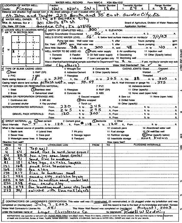
Specific Water Well Detail |
|
|
| Location Info | |||
| Owner: City of Garden City | Status: Constructed | ||
| Location: T24S, R32W, Sec. 18, NW NW SW | County: Finney | ||
| Directions: St. John and Taylor, 225 feet South and 35 feet East, Garden City | |||
| Latitude: 37.9668342 | Longitude: -100.8818103 | Datum NAD 27 | |
| Latitude: 37.9668573 | Longitude: -100.8822503 | Datum NAD 83 | |
| Longitude and latitude calculated by Survey from township-range-section-quarter calls. Only good to within the quarter call accuracy. | |||
| View well on interactive map | |||
| General Info | ||
| Well Depth: 300 ft. | Elevation: ft. | |
| Static Water Level: 56 ft. | Est. Yield: 1300 gpm. | |
| Comp. Date: 07-Jul-2003 | Well Use: Public Water Supply | |
| DWR Applic. #: | Other ID: | |
| Links | |
| No Wizard information available. | |
| View info from WIMAS Water Right Data base... | |
| Driller Info | ||
| Driller: Layne Western | License #: 581 | |
| Scanned Form | View scan |
|
Chemical Sample Submitted?:
Water Well disinfected?: | ||
| Casing Info | ||
| Casing Type:
Casing Joints: |
Diam: in. to ft | |
| Casing height above land surface: in
Casing Weight: lbs/ft Wall thickness or gauge no.: | ||
| Screen and Perforation Info | ||
| Screen Type: | Screen Openings: | |
| Screen-perforated intervals | From: ft to ft | |
| Gravel pack intervals | From: ft to ft | |
| Grout Info | ||
| Grout used: | From: to ft | |
| Source of Possible Contamination | ||
| Source: | ||
| Direction from well: | Distance: ft | |
| Lithologic Log
(Log data entered by KGS.) | ||
| From: 0 ft. to 4 ft. | topsoil | |
| From: 4 ft. to 54 ft. | sand, fine to med, large gravel | |
| From: 54 ft. to 80.5 ft. | tan clay some large gravel | |
| From: 80.5 ft. to 91 ft. | sand, fine to medium | |
| From: 91 ft. to 121 ft. | clay tan, caliche layers | |
| From: 121 ft. to 168 ft. | sand fine to medium | |
| From: 168 ft. to 170 ft. | tan clay | |
| From: 170 ft. to 217 ft. | fine to medium sand | |
| From: 217 ft. to 222 ft. | sandy clay, caliche layers | |
| From: 222 ft. to 250 ft. | fine to medium sand, water loss | |
| From: 250 ft. to 258 ft. | tan sandy clay | |
| From: 258 ft. to 293 ft. | fine to medium sand, some clay layers | |
| From: 293 ft. to 301 ft. | caliche with limerock layers | |