|
|
|
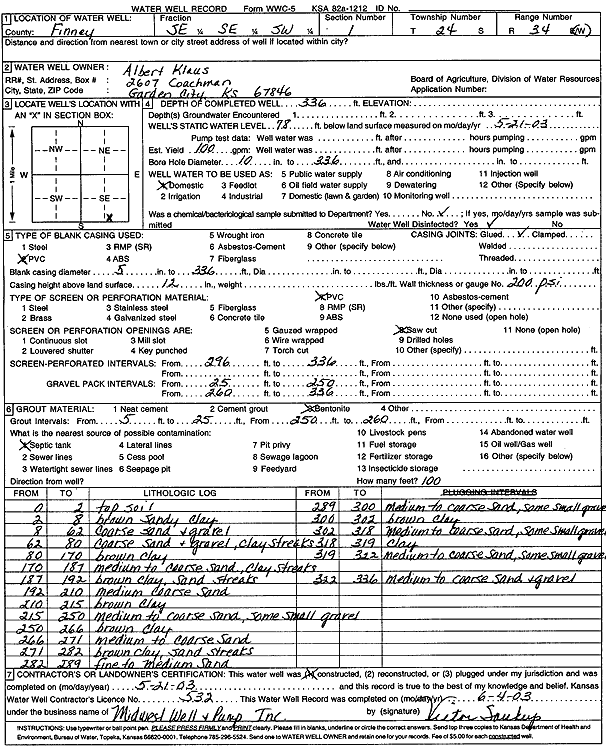
Specific Water Well Detail |
|
|
| Location Info | |||
| Owner: Klaus, Albert | Status: Constructed | ||
| Location: T24S, R34W, Sec. 1, SE SE SW | County: Finney | ||
| Directions: | |||
| Latitude: 37.9899591 | Longitude: -101.0031101 | Datum NAD 27 | |
| Latitude: 37.9899834 | Longitude: -101.0035546 | Datum NAD 83 | |
| Longitude and latitude calculated by Survey from township-range-section-quarter calls. Only good to within the quarter call accuracy. | |||
| View well on interactive map | |||
| General Info | ||
| Well Depth: 336 ft. | Elevation: ft. | |
| Static Water Level: 78 ft. | Est. Yield: 100 gpm. | |
| Comp. Date: 21-May-2003 | Well Use: Domestic | |
| DWR Applic. #: | Other ID: | |
| Driller Info | ||
| Driller: Midwest Well & Pump, Inc. | License #: 532 | |
| Scanned Form | View scan |
|
Chemical Sample Submitted?:
Water Well disinfected?: | ||
| Casing Info | ||
| Casing Type:
Casing Joints: |
Diam: in. to ft | |
| Casing height above land surface: in
Casing Weight: lbs/ft Wall thickness or gauge no.: | ||
| Screen and Perforation Info | ||
| Screen Type: | Screen Openings: | |
| Screen-perforated intervals | From: ft to ft | |
| Gravel pack intervals | From: ft to ft | |
| Grout Info | ||
| Grout used: | From: to ft | |
| Source of Possible Contamination | ||
| Source: | ||
| Direction from well: | Distance: ft | |
| Lithologic Log
(Log data entered by KGS.) | ||
| From: 0 ft. to 2 ft. | top soil | |
| From: 2 ft. to 8 ft. | brown sandy clay | |
| From: 8 ft. to 62 ft. | coarse sand and gravel | |
| From: 62 ft. to 80 ft. | coarse sand and gravel, clay streaks | |
| From: 80 ft. to 170 ft. | brown clay | |
| From: 170 ft. to 187 ft. | medium to coarse sand, clay streaks | |
| From: 187 ft. to 192 ft. | brown clay, sand streaks | |
| From: 192 ft. to 210 ft. | medium coarse sand | |
| From: 210 ft. to 215 ft. | brown clay | |
| From: 215 ft. to 250 ft. | medium to coarse sand, some small gravel | |
| From: 250 ft. to 266 ft. | brown clay | |
| From: 266 ft. to 271 ft. | medium to coarse sand | |
| From: 271 ft. to 282 ft. | brown clay, sand streaks | |
| From: 282 ft. to 289 ft. | fine to medium sand | |
| From: 289 ft. to 300 ft. | medium to coarse sand, some small gravel | |
| From: 300 ft. to 302 ft. | brown clay | |
| From: 302 ft. to 318 ft. | medium to coarse sand, some small gravel | |
| From: 318 ft. to 319 ft. | clay | |
| From: 319 ft. to 322 ft. | medium to coarse sand, some small gravel | |
| From: 322 ft. to 336 ft. | medium to coarse sand and gravel | |