|
|
|
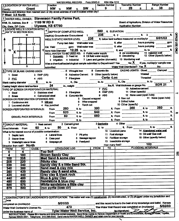
Specific Water Well Detail |
|
|
| Location Info | |||
| Owner: Stevenson Family Farms | Status: Constructed | ||
| Location: T28S, R38W, Sec. 9, NW NW SW | County: Grant | ||
| Directions: from Ulysses: 7 mi W, 3.5 mi N | |||
| Latitude: 37.6265102 | Longitude: -101.4885523 | Datum NAD 27 | |
| Latitude: 37.6265283 | Longitude: -101.4889998 | Datum NAD 83 | |
| Longitude and latitude calculated by Survey from township-range-section-quarter calls. Only good to within the quarter call accuracy. | |||
| View well on interactive map | |||
| General Info | ||
| Well Depth: 580 ft. | Elevation: ft. | |
| Static Water Level: 235 ft. | Est. Yield: gpm. | |
| Comp. Date: 01-May-2003 | Well Use: Domestic | |
| DWR Applic. #: | Other ID: | |
| Driller Info | ||
| Driller: Destal Tyler Water Well Service | License #: 473 | |
| Scanned Form | View scan |
|
Chemical Sample Submitted?:
Water Well disinfected?: | ||
| Casing Info | ||
| Casing Type:
Casing Joints: |
Diam: in. to ft | |
| Casing height above land surface: in
Casing Weight: lbs/ft Wall thickness or gauge no.: | ||
| Screen and Perforation Info | ||
| Screen Type: | Screen Openings: | |
| Screen-perforated intervals | From: ft to ft | |
| Gravel pack intervals | From: ft to ft | |
| Grout Info | ||
| Grout used: | From: to ft | |
| Source of Possible Contamination | ||
| Source: | ||
| Direction from well: | Distance: ft | |
| Lithologic Log
(Log data entered by KGS.) | ||
| From: 0 ft. to 4 ft. | Top Soil | |
| From: 4 ft. to 180 ft. | Brown Sandy Clay | |
| From: 180 ft. to 205 ft. | Med Sand and some clay | |
| From: 205 ft. to 220 ft. | Sticky clay | |
| From: 220 ft. to 340 ft. | Sandy clay and a little Sand Stk. | |
| From: 340 ft. to 360 ft. | Sand med and clay mix | |
| From: 360 ft. to 420 ft. | Sand clay and sand streaks. | |
| From: 420 ft. to 440 ft. | gray clay and black rock | |
| From: 440 ft. to 480 ft. | Blue and gray Clay | |
| From: 480 ft. to 500 ft. | Sandstone and blue clay | |
| From: 500 ft. to 575 ft. | White sandstone a little clay | |
| From: 575 ft. to 580 ft. | Iron pyrite (loss circulation) | |