|
|
|
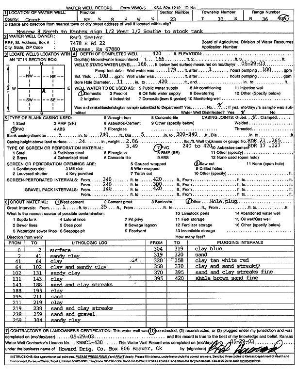
Specific Water Well Detail |
|
|
| Location Info | |||
| Owner: Teeter, Earl | Status: Constructed | ||
| Location: T30S, R36W, Sec. 23, NE SW | County: Grant | ||
| Directions: from Moscow: 8 mi N to Kantex sign, .5 mi W, .5 mi S to stock tank | |||
| Latitude: 37.4222571 | Longitude: -101.227309 | Datum NAD 27 | |
| Latitude: 37.4222807 | Longitude: -101.2277521 | Datum NAD 83 | |
| Longitude and latitude calculated by Survey from township-range-section-quarter calls. Only good to within the quarter call accuracy. | |||
| View well on interactive map | |||
| General Info | ||
| Well Depth: 420 ft. | Elevation: ft. | |
| Static Water Level: 166 ft. | Est. Yield: 100 gpm. | |
| Comp. Date: 29-May-2003 | Well Use: Domestic | |
| DWR Applic. #: | Other ID: | |
| Driller Info | ||
| Driller: Howard Drilling Company AG, LLC | License #: 430 | |
| Scanned Form | View scan |
|
Chemical Sample Submitted?:
Water Well disinfected?: | ||
| Casing Info | ||
| Casing Type:
Casing Joints: |
Diam: in. to ft | |
| Casing height above land surface: in
Casing Weight: lbs/ft Wall thickness or gauge no.: | ||
| Screen and Perforation Info | ||
| Screen Type: | Screen Openings: | |
| Screen-perforated intervals | From: ft to ft | |
| Gravel pack intervals | From: ft to ft | |
| Grout Info | ||
| Grout used: | From: to ft | |
| Source of Possible Contamination | ||
| Source: | ||
| Direction from well: | Distance: ft | |
| Lithologic Log
(Log data entered by KGS.) | ||
| From: 0 ft. to 2 ft. | surface | |
| From: 2 ft. to 41 ft. | sandy clay | |
| From: 41 ft. to 64 ft. | clay | |
| From: 64 ft. to 102 ft. | clay and sandy clay | |
| From: 102 ft. to 131 ft. | sandy clay | |
| From: 131 ft. to 143 ft. | clay | |
| From: 143 ft. to 188 ft. | sand and clay streaks | |
| From: 188 ft. to 195 ft. | clay | |
| From: 195 ft. to 211 ft. | sand | |
| From: 211 ft. to 219 ft. | clay | |
| From: 219 ft. to 238 ft. | sand and clay streaks | |
| From: 238 ft. to 259 ft. | sand and gravel | |
| From: 259 ft. to 304 ft. | sandy clay | |
| From: 304 ft. to 319 ft. | clay blue | |
| From: 319 ft. to 320 ft. | sand | |
| From: 320 ft. to 358 ft. | clay tan white red | |
| From: 358 ft. to 370 ft. | clay and sand streaks | |
| From: 370 ft. to 395 ft. | sand and clay streaks fine | |
| From: 395 ft. to 420 ft. | shale brown sand fine | |