|
|
|
Specific Water Well Detail |
|
|
| Location Info | |||
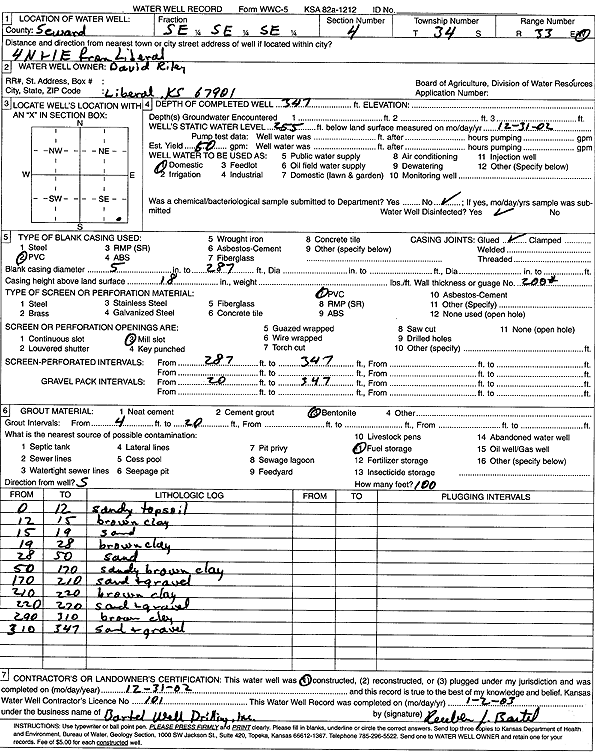
| Owner: Riley, David | Status: Constructed | ||
| Location: T34S, R33W, Sec. 4, SE SE SE | County: Seward | ||
| Directions: from Liberal: 4 mi N, 1 mi E | |||
| Latitude: 37.1132795 | Longitude: -100.9049352 | Datum NAD 27 | |
| Latitude: 37.113304 | Longitude: -100.9053771 | Datum NAD 83 | |
| Longitude and latitude calculated by Survey from township-range-section-quarter calls. Only good to within the quarter call accuracy. | |||
| View well on interactive map | |||
| General Info | ||
| Well Depth: 347 ft. | Elevation: ft. | |
| Static Water Level: 255 ft. | Est. Yield: 50 gpm. | |
| Comp. Date: 31-Dec-2002 | Well Use: Domestic | |
| DWR Applic. #: | Other ID: | |
| Driller Info | ||
| Driller: Bartel Well Drilling, Inc. | License #: 101 | |
| Scanned Form | View scan |
|
Chemical Sample Submitted?:
Water Well disinfected?: | ||
| Casing Info | ||
| Casing Type:
Casing Joints: |
Diam: in. to ft | |
| Casing height above land surface: in
Casing Weight: lbs/ft Wall thickness or gauge no.: | ||
| Screen and Perforation Info | ||
| Screen Type: | Screen Openings: | |
| Screen-perforated intervals | From: ft to ft | |
| Gravel pack intervals | From: ft to ft | |
| Grout Info | ||
| Grout used: | From: to ft | |
| Source of Possible Contamination | ||
| Source: | ||
| Direction from well: | Distance: ft | |
| Lithologic Log
(Log data entered by KGS.) | ||
| From: 0 ft. to 12 ft. | sandy topsoil | |
| From: 12 ft. to 15 ft. | brown clay | |
| From: 15 ft. to 19 ft. | sand | |
| From: 19 ft. to 28 ft. | brown clay | |
| From: 28 ft. to 50 ft. | sand | |
| From: 50 ft. to 170 ft. | sandy brown clay | |
| From: 170 ft. to 210 ft. | sand and gravel | |
| From: 210 ft. to 230 ft. | brown clay | |
| From: 230 ft. to 290 ft. | sand and gravel | |
| From: 290 ft. to 310 ft. | brown clay | |
| From: 310 ft. to 347 ft. | sand and gravel | |