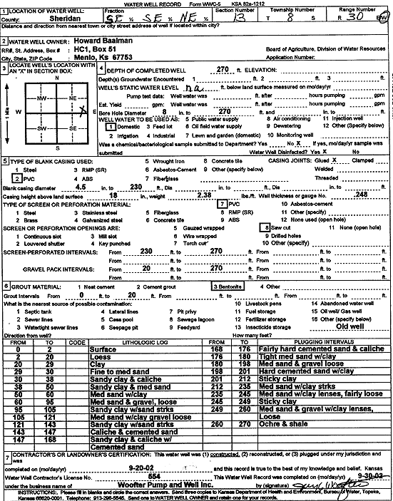
KGS Home Page Water Well Data base Specific Water Well Detail
Water Resources

Well T8S, R30W, Sec. 13, SE SE NE, Action: Constructed

Location Info
Owner: Baalman, Howard Status: Constructed
Location: T8S, R30W, Sec. 13, SE SE NE County: Sheridan
Directions:
Latitude: 39.3583681 Longitude: -100.6090396 Datum NAD 27
Latitude: 39.3583733 Longitude: -100.6094617 Datum NAD 83
Longitude and latitude calculated by Survey from township-range-section-quarter calls. Only good to within the quarter call accuracy.
View well on interactive map
General Info
Well Depth: 270 ft. Elevation: ft.
Static Water Level: ft. Est. Yield: gpm.
Comp. Date: 20-Sep-2002 Well Use: Domestic
DWR Applic. #: Other ID:
Driller Info
Driller: Jay C. Woofter Pump & Well, Inc. License #: 554
Scanned Form
View form(s) on screen Download scan(s)
The download files contain one or more TIFF images compressed into a ZIP archive. Your browser may be already set up to decompress these files. The TIFFs are 300 dpi archival-quality scans of the WWC5 forms and can be viewed by software like Adobe PhotoShop.
Chemical Sample Submitted?:
Water Well disinfected?:
Casing Info
Casing Type:
Casing Joints:
Diam: in. to ft
Casing height above land surface: in
Casing Weight: lbs/ft
Wall thickness or gauge no.:
Screen and Perforation Info
Screen Type: Screen Openings:
Screen-perforated intervals From: ft to ft
Gravel pack intervals From: ft to ft
Grout Info
Grout used: From: to ft
Source of Possible Contamination
Source:
Direction from well: Distance: ft
Lithologic Log
(Log data entered by KGS.)
From: 0 ft. to 2 ft. Surface
From: 2 ft. to 20 ft. Loess
From: 20 ft. to 29 ft. Clay
From: 29 ft. to 30 ft. Fine to medium sand
From: 30 ft. to 38 ft. Sandy clay and caliche
From: 38 ft. to 50 ft. Sandy clay and medium sand
From: 50 ft. to 60 ft. Medium sand with clay
From: 60 ft. to 95 ft. Medium sand and gravel, loose
From: 95 ft. to 105 ft. Sandy clay with sand streaks
From: 105 ft. to 121 ft. Medium sand with clay, gravel loose
From: 121 ft. to 143 ft. Sandy clay with sand streaks
From: 143 ft. to 147 ft. Caliche and cemented sand
From: 147 ft. to 168 ft. Sandy clay and caliche with cemented sand
From: 168 ft. to 176 ft. Fairly hard cemented sand and caliche
From: 176 ft. to 180 ft. Tight medium sand with clay
From: 180 ft. to 198 ft. Medium sand and gravel loose
From: 198 ft. to 201 ft. Hard cemented sand with clay
From: 201 ft. to 212 ft. Sticky clay
From: 212 ft. to 235 ft. Medium sand with clay streaks
From: 235 ft. to 245 ft. Medium sand with clay lenses, fairly loose
From: 245 ft. to 249 ft. Stick clay
From: 249 ft. to 260 ft. Medium sand and gravel with clay lenses, loose
From: 260 ft. to 270 ft. Ochre, shale

Kansas Geological Survey
Comments to kgs-webadmin@ku.edu
URL=http://www.kgs.ku.edu/Magellan/WaterWell/index.html
Display Programs Updated January 2, 2025
Data added continuously.