|
|
|
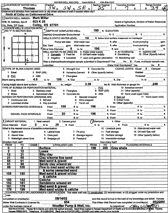
Specific Water Well Detail |
|
|
| Location Info | |||
| Owner: Miller, Mark | Status: Constructed | ||
| Location: T7S, R34W, Sec. 25, SW SW SE | County: Thomas | ||
| Directions: from Colby: N on Cottonwood Dr | |||
| Latitude: 39.4097329 | Longitude: -101.0624033 | Datum NAD 27 | |
| Latitude: 39.4097363 | Longitude: -101.0628366 | Datum NAD 83 | |
| Longitude and latitude calculated by Survey from township-range-section-quarter calls. Only good to within the quarter call accuracy. | |||
| View well on interactive map | |||
| General Info | ||
| Well Depth: 196 ft. | Elevation: ft. | |
| Static Water Level: ft. | Est. Yield: gpm. | |
| Comp. Date: 14-Aug-2002 | Well Use: Domestic | |
| DWR Applic. #: | Other ID: | |
| Driller Info | ||
| Driller: Jay C. Woofter Pump & Well, Inc. | License #: 554 | |
| Scanned Form | View scan |
|
Chemical Sample Submitted?:
Water Well disinfected?: | ||
| Casing Info | ||
| Casing Type:
Casing Joints: |
Diam: in. to ft | |
| Casing height above land surface: in
Casing Weight: lbs/ft Wall thickness or gauge no.: | ||
| Screen and Perforation Info | ||
| Screen Type: | Screen Openings: | |
| Screen-perforated intervals | From: ft to ft | |
| Gravel pack intervals | From: ft to ft | |
| Grout Info | ||
| Grout used: | From: to ft | |
| Source of Possible Contamination | ||
| Source: | ||
| Direction from well: | Distance: ft | |
| Lithologic Log
(Log data entered by KGS.) | ||
| From: 0 ft. to 2 ft. | surface | |
| From: 2 ft. to 12 ft. | loess | |
| From: 12 ft. to 21 ft. | silty clay | |
| From: 21 ft. to 55 ft. | clay with some fine sand | |
| From: 55 ft. to 61 ft. | medium sand and gravel | |
| From: 61 ft. to 88 ft. | sandy clay with sand streaks | |
| From: 88 ft. to 105 ft. | fine to medium sand with clay streaks and some cemented sand | |
| From: 105 ft. to 150 ft. | medium sand and gravel with clay and caliche | |
| From: 150 ft. to 152 ft. | caliche | |
| From: 152 ft. to 161 ft. | sandstone with sand streaks | |
| From: 161 ft. to 179 ft. | medium sand and gravel | |
| From: 179 ft. to 196 ft. | medium sand with clay and caliche | |
| From: 196 ft. to 200 ft. | gray shale | |